Nations Online
All Countries in the World
|
One Planet Nations Online All Countries in the World | |
Home  |
___ Satellite View and Map of the City of Frankfurt (Main), Germany |
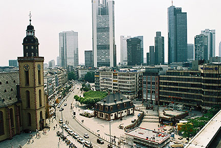
About Frankfurt (Main) Satellite view is showing Frankfurt (Main), the largest city in the German state of Hesse, located on the river Main in the center of Satellite view is showing Frankfurt (Main), the largest city in the German state of Hesse, located on the river Main in the center of  Alte Wache and St.-Katharinen Church in Frankfurt's Central Business District. Image: © Nations Online Project Frankfurt ranks among the top 10 most livable cities in the world (according to Mercer). According to GaWC 2008, Frankfurt is Germany's only Alpha World City. The city is the largest financial center in continental Europe and home to the European Central Bank, Deutsche Bundesbank, Frankfurt Stock Exchange and about 200 national and international commercial banks. One of the most famous natives of Frankfurt, poet and writer Johann Wolfgang von Goethe was born in the city in 1749. Just zoom in (+) to see Frankfurt's Opera House (Alte Oper) close to the Business District. The Map shows a city map of Frankfurt (Main) with expressways, main roads and streets, zoom out to find the location of Frankfurt Airport (Flughafen Frankfurt am Main, IATA code: FRA), one of the busiest airports in Europe, it serves as the hub for German flag carrier Lufthansa, and is the biggest cargo airport in Europe, situated in south west of the city. Zoom out to find the location of Airport Frankfurt-Hahn (IATA code: HHN), located about 120 km (75 mi) west of the city. To find a location use the form below. |
|
| To find a location type: street or place, city, optional: state, country. |
Local Time Frankfurt:
Thursday-April-25 22:32
Standard Time Zone (CET): UTC/GMT +1 hourCEST (Daylight Saving Time) in use from end of March until end of October. Time zone offset: UTC/GMT +2 hours |
|
φ Latitude, λ Longitude (of Map center; move the map to see coordinates): , |
||||||
| Google Earth: Searchable map and satellite view of Frankfurt (Main), Germany. City Coordinates: 50°6′37″N 8°40′56″E |
Bookmark/share this page
|
|||||
|
More about Germany: Landmarks: Searchable map/satellite view of some major cities in Germany: Berlin, Bremen, Dresden, Düsseldorf, Erfurt, Hamburg, Hannover, Kiel, Köln (Cologne), Magdeburg, Mainz, München (Munich), Saarbrücken, Schwerin, Stuttgart, Wiesbaden Bundesland (State): Country: Continent: |
Weather Conditions Frankfurt: External Links: Stadt Frankfurt (Main) Official web site of the City of Frankfurt/Main. Frankfurt Airport (FRA) Official web site of Germany's largest airport. Frankfurter Allgemeine Zeitung Nationwide newspaper (in German) Wikipedia: Frankfurt (Main) |
Explore more:
Related Consumer Information:
|
||||
Europe's Alpha Cities Tour: Rome - Zürich - Madrid - Paris - Amsterdam London - Stockholm - Berlin - Prague - Vienna - Istanbul Other Major Cities in Western Europe Bern, Bordeaux, Brussels, Cannes, Cologne, Den Hague, Dresden, Düsseldorf, Geneva, Hamburg, Luxembourg (City), Lyon, München, Monaco, Nice, Rotterdam, Strasbourg, Stuttgart, Toulouse, Vaduz, Vienna |
One World - Nations Online .:. let's care for this planet Promote that every nation assumes responsibility for our world. Nations Online Project is made to improve cross-cultural understanding and global awareness. More signal - less NOISE |
| Site Map
| Information Sources | Disclaimer | Copyright © 1998-2023 :: nationsonline.org |