About Myanmar
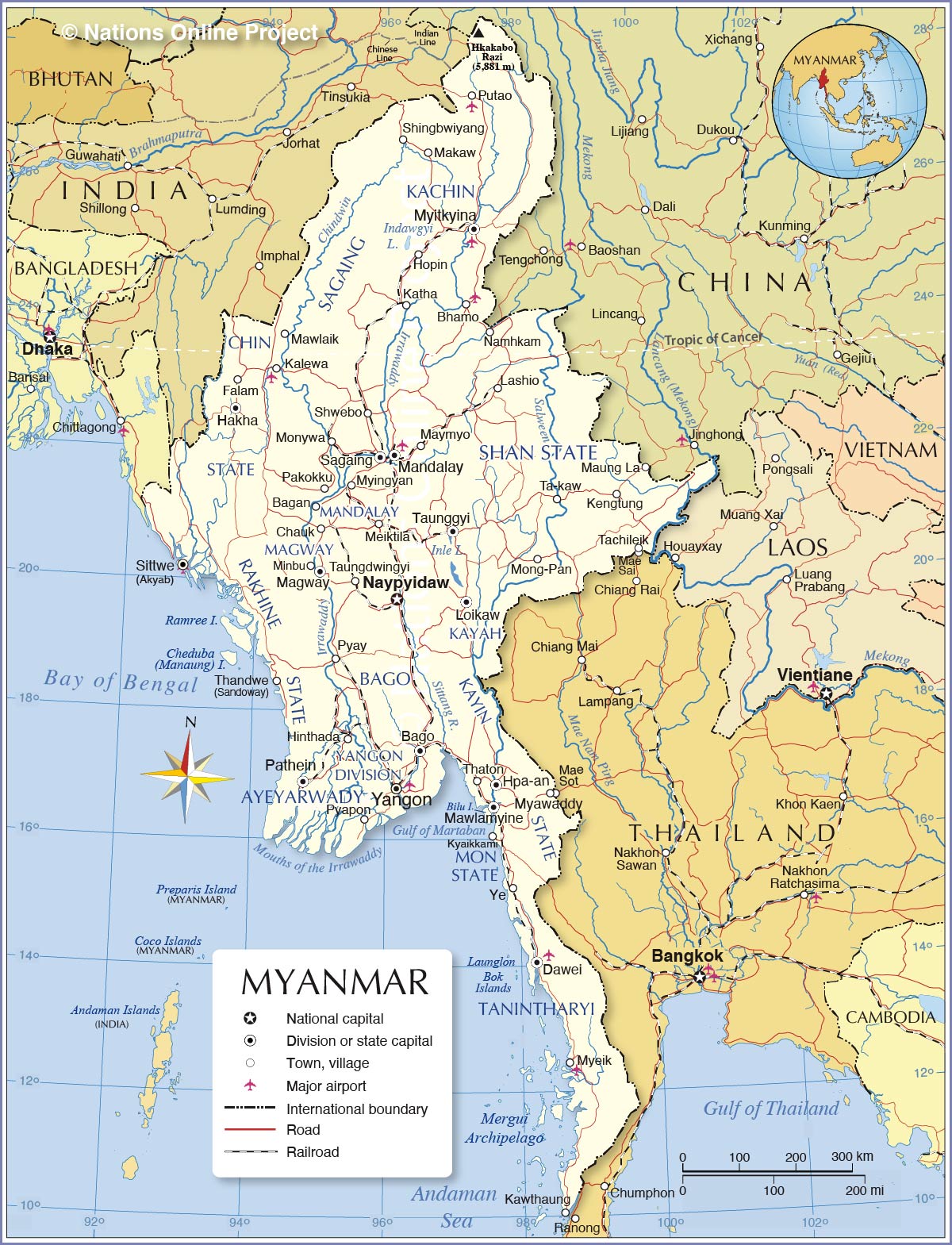
The map shows Myanmar, the northernmost and largest country in Southeast Asia. It is also known as Burma and the Golden Land. Myanmar is bounded in the south and southwest by the Bay of Bengal, the Gulf of Mottama and the Andaman Sea. It borders
China in the north and northeast,
Bangladesh and the
Indian states of
Nagaland,
Manipur and
Mizoram in the northwest and west and
Thailand in the southeast. The Mekong River forms its border with
Laos, the region of the
Golden Triangle.
The country covers an
area of 676,578 km², making it almost twice the size of
Germany or slightly smaller than the US state of
Texas.
Myanmar has a
population of 55 million people (in 2021). The largest city, former capital and the economic center of Myanmar is Yangon (Rangoon). Since 2005 Burma's new (administrative) capital is
Naypyidaw, a planned city in the country's central part. Spoken
languages are Burmese (official); Kachin, Kayah, Karen, Chin, Mon, Rakhine, and Shan are major regional languages.
More about Myanmar
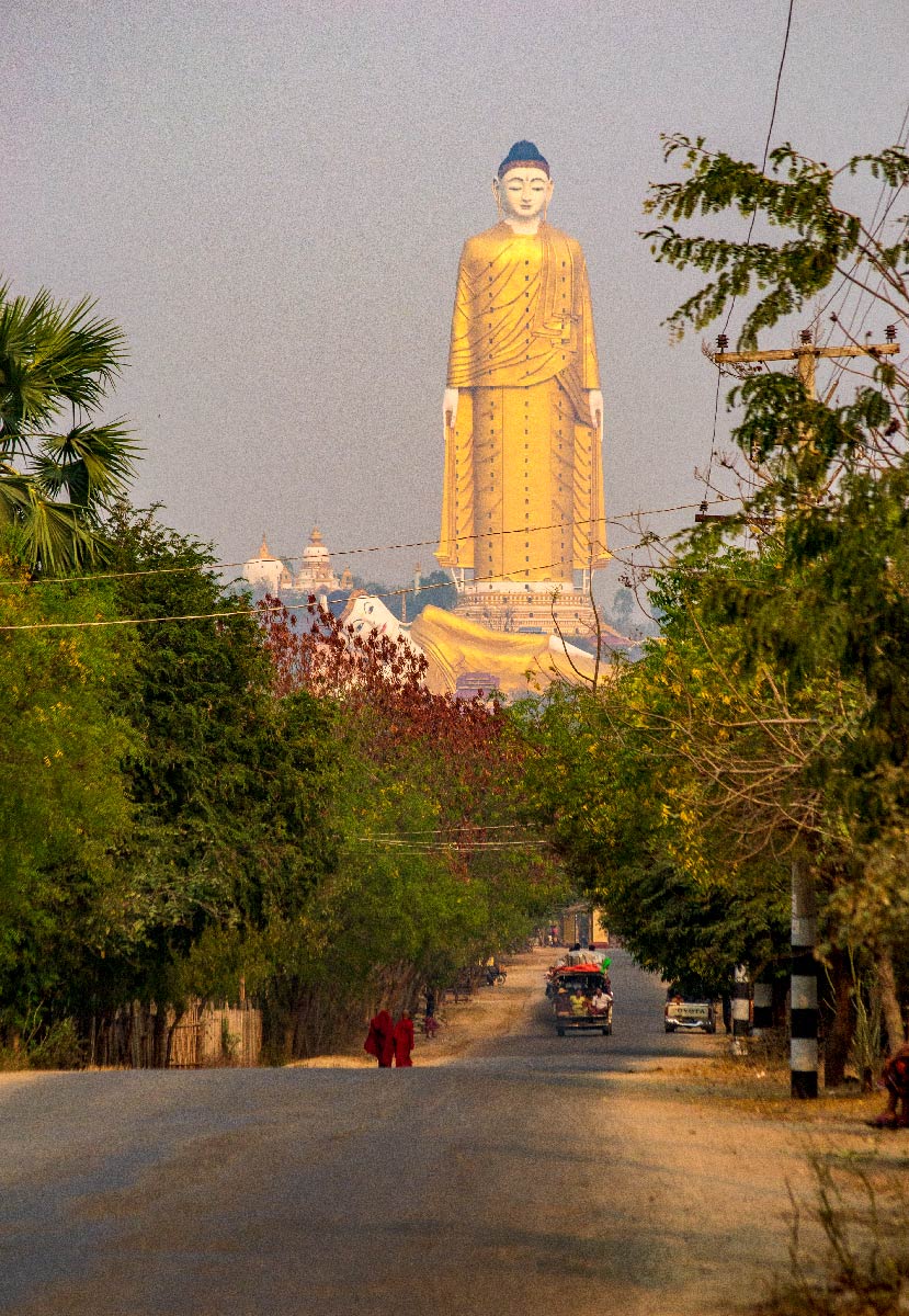
 The Laykyun Sekkya Buddha, known as the Giant Buddha, in the Maha Bodhi Tahtaung region, near Monywa (Sagaing Region). Laykyun Sekkya is a colossal statue representing a standing Buddha, 116 m high, with 31 floors and an elevator inside.
Photo: kk nationsonline.org
Myanmar is gifted with great biogeophysical diversity.
There are the coastal areas with tropical evergreen forests with Malay fauna and flora along the Bay of Bengal and the Andaman Sea in the south.
The densely populated fertile
Irrawaddy Delta in the central south was the country's breadbasket; nearly 60 percent of its total rice crop came from the river delta.
The
Chin Hills-Arakanto mountains (also known as the Rakhine Mountains) in the west are covered by mountain forests and form a natural border with India.
In central Myanmar are the irrigated fields of the dry zone of the Ayeyawady River (Irrawaddy), and in the far north are the snow-capped mountains with flora and fauna of the Himalayas.
The Shan state in the central-western part of the country is dominated by the rolling hills and mountains of the
Shan Highland (Shan Plateau).
The narrow coastal region of southeastern Myanmar is dominated by the Tenasserim Range (Tanintharyi), a roughly 1,700 km long mountain chain. Part of the Tanintharyi Region is the
Mergui Archipelago, consisting of more than 800 islands of varying sizes.
Myanmar's highest mountain
The highest mountain in Myanmar and Southeast Asia is Mount
Hkakabo Razi (Khaka Borazi), at 5,881 m (19,295 ft). The peak is located in a subrange of the Greater Himalayan mountain system in Kachin state near the country's northern border with China, about 110 km (70 mi) north of the city of Putao.
Rivers and Lakes
Burma's main rivers are the
Chindwin (the 'Mighty Chindwin') and the
Irrawaddy (Ayeyarwady). Other major rivers are the Salween River (Thanlwin) and the Sittaung River.
The country's largest lake is
Indawgyi Lake, located about 100 km southwest of Myitkyina, the capital of Kachin State. Myanmar's most famous lake is
Inle Lake, situated 25 km south of Taunggyi, the capital and largest city of Shan State. Connected to Inle Lake by the Belu Chaung River is the 50 km long
Samkar Lake, also known as the South Lake.
Administrative Divisions of Myanmar
Myanmar is divided into seven states (pyine) and seven divisions (yin).
The
Divisions are (division capital in brackets): Ayeyarwady Division (Pathein) | Bago Division (Bago) | Magway Division (Magway) | Mandalay Division (Mandalay) | Sagaing Division (Sagaing) | Tanintharyi Division (Dawei) | Yangon Division (Yangon)
The
States are (state capital in brackets):
Chin State (Hakha) | Kachin State (Myitkyina) | Kayin also Karen State (Hpa-an) | Kayah, also Karenni State (Loikaw) | Mon State (Mawlamyine) | Rakhine State (Sittwe) | Shan State (Taunggyi).
Airports
The principal airports of Myanmar are Yangon International Airport (
IATA code: RGN) near Yangon and Mandalay International Airport (IATA: MDL), the second of only two international airports in all of Myanmar.
There are regional airports at Bhamo (IATA: BMO), Dawei (IATA: TVY), Heho (IATA: HEH), Kalaymyo (IATA: KMV), Myeik (Mergui; IATA: MGZ), Myitkyina (IATA: MYT), Nay Pyi Taw (IATA: NYT), Putao (IATA: PBU) and Sittwe (IATA: AKY).


