Nations Online
All Countries in the World
Nations Online All Countries in the World | |
Home  |
___ Satellite View and Map of the City of Yangon (ရန်ကုန်) |
About YangonYangon is situated in the Irrawaddy delta, in the southwest of the country. 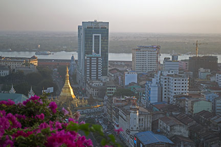 Yangon with Sule Pagoda at dawn, Yangon River in background. Image: © nationsonline.org Yangon is since centuries a Buddhist religious center, it is the site of the Shwedagon Pagoda, built over 2,500 years ago. Just zoom in (+) to see the Shwedagon Pagoda. The map shows a city map of Yangon with expressways, main roads and streets, zoom out to find the location of Yangon International Airport (IATA code: RNG) located at Mingaladon in a distance of 15 km (9.5 mi) by road (via Pyay Road) north of the city. To find a location use the form below. To view just the map, click on the "Map" button. |
|
| To find a location type: street or place, city, optional: state, country. |
Local Time Yangon:
Saturday-July-4 13:46
UTC/GMT +6:30 hours |
|
φ Latitude, λ Longitude (of Map center; move the map to see coordinates): , |
||||||
| Google Maps: Searchable map/satellite view of Yangon, Myanmar. Coordinates: 16°48′N 96°09′E | Bookmark/share this page |
|||||
| More about Myanmar: Images: Landmarks: Cities: Satellite View of the administrative capital. Country: Myanmar key statistical data. Continent: |
Current Weather Conditions Yangon:
External Links: Wikipedia: Yangon |
Explore more:
Related Consumer Information:
|
||||
| Other Major Cities
in South East Asia: Bandar Seri Begawan, Bandung, Bangkok, Hanoi, Ho Chi Minh City (Saigon), Jakarta, Johor Bahru, Kuala Lumpur, Manila, Medan, Phnom Penh, Singapore, Surabaya, Vientiane Searchable Maps of other Countries in South East Asia: Brunei, Cambodia, Indonesia, Laos, Malaysia, Myanmar (Burma), Philippines, Singapore, Thailand, Vietnam |
||
Map Help [ show ] |
||
One World - Nations Online .:. let's care for this planet Promote that every nation assumes responsibility for our world. Nations Online Project is made to improve cross-cultural understanding and global awareness. More signal - less NOISE |
| Site Map
| Information Sources | Disclaimer | Copyright © 1998-2024:: nationsonline.org |

