| Home |
|
 |
|
___ Reference Map of Oceania/Australia |
|
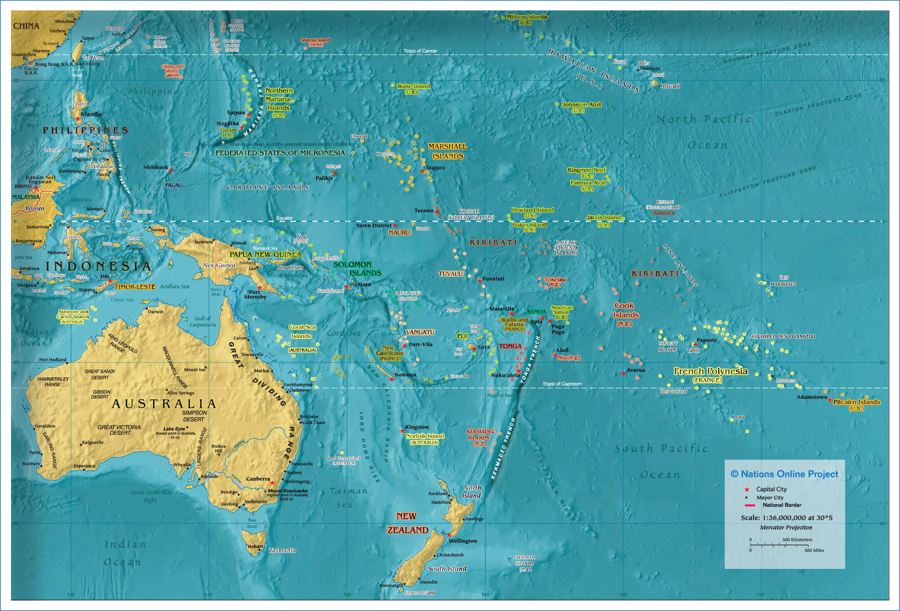
Oceania/Australia MapOceania is an area that encompasses the islands of the tropical Ocean and adjacent seas, also known as the South West Pacific.It is a vast region (8.5 million km²) mostly consisting of water, largest landmass in Oceania is Australia. Countries and Territories of Oceania/Australia Oceania is divided in three subregions of Melanesia, Micronesia, and Polynesia. Melanesia is a region in the western Pacific Ocean, south of Micronesia and west of Polynesia. Its area includes the Island States and Territories of Fiji, New Caledonia, West Papua which is part of Indonesia, Papua New Guinea, the Solomon Islands, Vanuatu and the Bismarck Archipelago, another island group, which includes New Britain, New Ireland, and several hundred other islands. Micronesia is situated north of Melanesia and north and west of Polynesia. It includes the Island States and Territories Kiribati, the Marshall Islands, the Federated States of Micronesia, Nauru, the Marianas with the Commonwealth of the Northern Mariana Islands (CNMI) and Guam, and the Caroline islands with Palau. Polynesia lies east of Micronesia and Melanesia and contains the easternmost of the three large groups of Pacific islands, including the Cook Islands , the Marquesas Islands that forms part of French Polynesia (Tahiti), the Samoan islands with (Western) Samoa and American Samoa, Niue, an island territory annexed by New Zealand, the Kingdom of Tonga, Tuvalu (formerly called the Ellice Islands) and Pitcairn, a British overseas territory inhabited by the descendants of the mutineers from HMS Bounty and the Tahitians who accompanied them . Hawaii,, Samoa, the Cook Islands, and French Polynesia. Interactive map of the countries in Oceania/Australia. Click on the country name on the map to get to the respective country profile page, or use the links below. Country maps will be found on the respective country page. |
Bookmark/share this page
|
 One World - Nations Online all countries of the world |
|
|
|||||
|
back to small map of Oceania/Australia.  Oceania map shows oceans, regions, states, territories, and island states of Oceania/Australia with capitals, major cities, and major rivers. |
| Related Categories: | Political Maps of: | Searchable Maps of Countries and Island Nations in the South Pacific: | Searchable Maps of Capital Cities in the South Pacific: | ||
Region Maps: Country/Territory Maps | American Samoa Australia Fiji Guam Kiribati Marshall Islands Micronesia Nauru New Caledonia New Zealand |
Northern Mariana Islands Palau Papua New Guinea Samoa Solomon Islands Tahiti Tonga Tuvalu Vanuatu |
Apia Canberra Funafuti Hagåtña (Agana) Honiara Honolulu Majuro Ngerulmud, Melekeok | Nouméa Nuku'alofa Pago Pago Palikir Papeete Port Moresby Port-Vila Saipan Suva Wellington | |
One World - Nations Online .:. let's care for this planet Every nation is responsible for the current state of our world. |
| Site Map
| Information Sources | Disclaimer: Privacy Policy, etc. Contact: [email protected] | Copyright © 1998-2021 :: nationsonline.org |
One World - Nations Online .:. let's care for this planet Promote that every nation assumes responsibility for our world. Nations Online Project is made to improve cross-cultural understanding and global awareness. More signal - less NOISE |
| Site Map
| Information Sources | Disclaimer | Copyright © 1998-2023 :: nationsonline.org |