One World
Nations Online
One World Nations Online |
|
| Home |
 Port Vila on Efate Island, view from Montmartre in the outskirts of the capital. Image: Phillip Capper |
___ Vanuatu Location map of Vanuatu The Republic of Vanuatu is an island nation in the South Pacific Ocean, northeast of New Caledonia, east of Australia and west of Fiji. The Y-shaped chain of fourteen main islands between the South Pacific Ocean and the Coral Sea is of volcanic origin and home to several active volcanoes. The colliding Pacific and Indo-Australian continental plates provide for geological activities like earthquakes, tsunamis, cyclones, and volcanic eruptions, hardly tourist attractions. But Mount Yasur on Tanna Island is an easily accessible active volcano, and a major Vanuatu tourist attraction, especially at night. Highest point is Mount Tabwemasana, at 1,879 m (6,165 ft), located on the island of Espiritu Santo. The combined land area of the islands is 12,189 km², this is about the size of the Falkland Islands, or slightly larger than Connecticut. The archipelago has a population of 278,000 (in 2015), capital and largest city is Port Vila. Spoken languages are Bislama (English-based creole), English, French and various Austronesian languages. |
Republic of Vanuatu |
Country Profile |
Background: British and French settled the islands in the 19th century, they agreed in 1906 to administer the islands jointly, called the British-French Condominium, which last until independence in 1980. Vanuatu is recognized as one of the most culturally diverse countries in the world. Besides the Ni-Vanuatu and other Pacific Island people, there are small communities of French, British, Australian, New Zealand, Vietnamese, and Chinese origin. related countries: France, United Kingdom other Melanesian nations and territories: Fiji, New Caledonia, Papua New Guinea, Solomon Islands |
Official Name: Republic of Vanuatu short form: Vanuatu former: New Hebrides ISO Country Code: vu, vut Time: Local Time = UTC +11h Actual Time: Wed-July-15 15:35 Country Calling Code: +678 Capital City: Port Vila (on the island of Efate; pop. 30 000) Other Cities: Luganville (on the island of Espiritu Santo, also known as Santo). Government: Type: Parliamentary democracy. Independence: 30 July 1980 (from France and UK) . Constitution: 30 July 1980. Geography: Location: Oceania, group of islands in the South Pacific Ocean, east of Australia and west of Fiji. Area: 14,760 km² (5,697 sq miles). Terrain: Mostly mountains of volcanic origin, narrow coastal plains. Climate: Maritime tropical; moderate rainfall from November to April. People: Nationality: Noun and adjective: ni-Vanuatu. Population: 278,000 (2015, National Statistics). Ethnic groups: 94% ni-Vanuatu; 4% European; 2% other Pacific Islanders, Asian. Religion: Predominantly Christian. Languages: 3 official languages: English, French and Bislama (pidgin English), plus over 120 distinct languages. Literacy: 53% Natural resources: Manganese, hardwood forests, fish. Agriculture products: Copra, coconuts, cocoa, coffee, taro, yams, coconuts, fruits, vegetables; fish, beef. Exports - commodities: copra, beef, cocoa, timber, kava, coffee Exports partners: Japan 35.1%, Turkey 10.5%, Thailand 8.7%, China 8.2%, Venezuela 5.9%, UK 5.6% (2015) Imports - commodities: machinery and equipment, foodstuffs, fuels Imports partners: China 16.7%, Australia 14.6%, Japan 13.9%, Singapore 10%, Fiji 9.3%, NZ 8.3%, New Caledonia 5.2% (2015) Currency: Vatu (VUV) Sources: Vanuatu Statistics Office and others. |
|
Note: External links will open in a new browser window. Official Sites of VanuatuGovernment of VanuatuOfficial site of the Government of the Republic of Vanuatu. Intergovernmental organisations Pacific Islands Forum Inter-governmental organization for the cooperation between the countries of the Pacific Ocean. Secretariat of the Pacific Community (SPC) Intergovernmental organisation of the Pacific islands. Statistics Vanuatu Statistics Office Vanuatu's official statistical agency. Weather Vanuatu Meteorological Service Vanuatu weather from Port Vila Forecasting Centre. MapsAdministrative Map of VanuatuShaded relief map of Vanuatu with provinial borders. Searchable map and satellite view of Vanuatu. Searchable map and satellite view of Vanuatu. Map of the Island States of Melanesia. Reference Map of Oceania and the Pacific Islands.  Mount Yasur on Tanna Island, the lava explosions are a major tourist attraction. Image: Christopher Hogue Thompson |
NewsLoop Loop Pacific, coverage of news, sports, entertainment, etc. Vanuatu Daily Post, Port Vila Vanuatu News in English. Vanuatu Daily Digest What the Vanuatu news media are saying, with added spice. |
Bookmark/share this page |
Arts & CultureCultural Vanuatu Vanuatu is rich in cultural festivals not seen anywhere else in the world, ranging from the death defying Pentecost Land Dive (nagol), to the colorful and powerful Tanna Toka Dance which goes on for days, the mystical Rom dance of Ambrym island of magic and fire, and Water Music custom festival performed by the women of Gaua Island. ... read more Further Arts Vanuatu Music, Dance and Culture portal of Vanuatu. Vanuatu arts & entertainment Cultural & Community tours. |
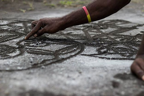 Vanuatu Art © Further Arts Vanuatu |
Business & EconomyVanuatu Investment Promotion Authority Investing in Vanuatu. Vanuatu Customs and Inland Revenue Website Vanuatus custom. Transportation Air Vanuatu Vanuatu's carrier, a wholly owned company of the government of the Republic of Vanuatu. Vanair Vanuatu's domestic carrier, in 2004 Vanair merged with Vanuatu's government-owned flag carrier, Air Vanuatu. |
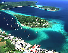 Efate - Port Vila Harbour |
 Erakor Island and Peninsula from Panorama Crescent, Port Vila. Image: Phillip Capper Travel and Tour Consumer Information
Destination Vanuatu
Discover Vanutu islands: Banks and Torres, Espiritu Santo, Maewo, Pentecost, Malekula,
Ambrym, Epi, Efate, Erromango, Tanna, Aneityum. |
EducationUniversity of the South Pacific Premier institution of tertiary education in the Pacific region, jointly owned by the governments of twelve island countries, USP is an international centre of excellence for teaching, research and consulting on all aspects of Pacific life. University of the South Pacific Libraries The Main Library of the University of the South Pacific based at Laucala Campus, Suva, Fiji. |
Environment & NatureVanuatu Environmental Science Society VESS’ promotes science in the fields of conservation, environmental protection and sustainable development within Vanuatu. Vanuatu's Biodiversity Comprehensive information about Vanuatu's Biodiversity projects. South Pacific Regional Environment Programme (SPREP) The Pacific region's major intergovernmental organisation charged with protecting and managing the environment and natural resources. |
HistoryHistory Explore Vanuatu’s rich cultural history and its role in World War 2. Timeline : Vanuatu A timeline of Vanuatu's history, the country formerly known as the New Hebrides. History of Vanuatu Wikipedia article about Vanuatu's history. |
|
Other island territories and states in the South Pacific: American Samoa | Fiji| Kiribati| New Caledonia | Papua New Guinea| Samoa Solomon Islands | Tahiti | Tonga | Tuvalu |
One World - Nations Online .:. let's care for this planet Promote that every nation assumes responsibility for our world. Nations Online Project is made to improve cross-cultural understanding and global awareness. More signal - less NOISE |
| Site Map
| Information Sources | Disclaimer | Copyright © 1998-2024:: nationsonline.org |