Nations Online
All Countries in the World
Nations Online All Countries in the World | |
Home  |
___ Satellite View and Map of the City of Majuro, Marshall Islands |
Searchable Map and Satellite View of Majuro using Google Earth DataSatellite view is showing Majuro, an atoll in the Ratak (eastern chain of RMI), the city of Majuro on the island is the largest city and national capital the Republic ofMajuro has a population of about 25,000 inhabitants. Spoken languages are English (official) and local Austronesian languages. Just zoom in to see the Capitol Building, seat of the government. The map shows a city map of Majuro with main roads and streets, zoom out to find the location of Majuro Airport (IATA code: MAJ). To find a location use the form below. To view just the map, click on the "Map" button. Map Help |
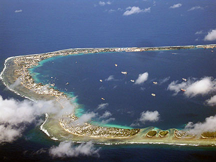 Aerial view of Majuro Image: tomandsharonshaw |
| To find a location type: street or place, city, optional: state, country. |
Local Time Marshall Islands:
Saturday-June-20 01:33
Time zone: Marshall Islands Time (MHT) :: UTC/GMT +12 hours |
|
φ Latitude, λ Longitude (of Map center; move the map to see coordinates): , |
||||||
| Google Earth: Searchable Map and Satellite view of Majuro, Marshall Islands. |
||||||
| More about the Marshall Islands: External Link Wikipedia: Majuro |
Current Weather Conditions Marshall Islands: Nearest weather station at Guam
|
Related Consumer Information:
|
||||
Other Micronesian Island Nations: Guam, Hawaii, Kiribati, Federated States of Micronesia, Nauru, Northern Mariana Islands, Palau Countries and territories of Australia/Oceania Countries of the World: A - C | D - G | H - L | M - P | Q - T | U - Z Continents: Africa | The Americas | Asia | Europe |
||||||
Map Help [ show ] |
||||||
One World - Nations Online .:. let's care for this planet Promote that every nation assumes responsibility for our world. Nations Online Project is made to improve cross-cultural understanding and global awareness. More signal - less NOISE |
| Site Map
| Information Sources | Disclaimer | Copyright © 1998-2024:: nationsonline.org |

