One World
Nations Online
One World Nations Online |
|
| Home |
___ Guam |
 Guam shore near Ritidian Point, Guam National Wildlife Refuge. Image: U.S. Fish and Wildlife Service |
 Location map of Guam Guam is situated about 2,200 km (1,300 mi) east of the Philippines, about 1,800 km (1,100 mi) north of Papua New Guinea, 6.400 km (4,000 mi) west of Hawaii and 3,400 km (2,100 mi) south east of North Korea! The island lies on about the same latitude as Bangkok, Thailand. Guam is the southernmost island of the Marianas Island Arc, a submerged mountain range that extends 2,500 km (1,550 mi) from Guam in south to near Japan. Guam is situated within Micronesia, a subregion of Oceania. The chain of islands stretches along the Mariana Trench, a deep depression in the ocean floor and the deepest part of the world's oceans. The Challenger Deep south of Guam is the deepest known point in the Earth's seabed hydrosphere, with a depth of 10,898 to 10,916 m. Guam is an organized unincorporated territory of the USA, its capital is Hagåtña (Agana), largest city is Dededo (pop. 6,500). Apra (Harbor), is one of the largest deep water ports in the Western Pacific. The island is served by Guam International Airport (Antonio B. Won Pat International Airport). Guam has a population of 162,800 people (in 2016), the largest ethnic group are the native Chamorros with 37%. Roman Catholicism is the predominant religion. |
Territory of Guam | Guahan |
Country Profile |
|
Official Name: Territory of Guam short form: Guam local form: Guahan (Guåhan) ISO Country Code: gu Time: Timezone: Chamorro Standard Time Local Time = UTC +10h Actual Time: Sat-July-4 02:13 Country Calling Code: +1 671 Capital City: Hagåtña (formerly Agana) Other Cities: Agat, Merizo, Yigo Government: Organized, unincorporated territory of the US. Geography: Location: Oceania, island in the North Pacific Ocean, east of the Philippines and north of Papua New Guinea. Area: 549 km² (212 square miles) Terrain: volcanic origin, surrounded by coral reefs, low hills in center, mountains in south. Climate: Tropical marine; warm and humid with little seasonal temperature variation, dry season from January to June, rainy season from July to December. People: Nationality: Guamanian(s) Population: 162,800 (in 2016) Ethnic Groups: Chamorro 37%, Filipino 26%, white 10%, Asian and other 27% Religions: Roman Catholic 85%, other 15% Languages: English, Chamorro, Japanese Literacy: 99% Natural resources: Fishing (largely undeveloped), tourism. Agriculture products: Fruits, copra, vegetables; eggs, pork, poultry, beef . Industries: US military, tourism, construction, transshipment services, concrete products, printing and publishing, food processing, textiles. Exports partners: Palau (72%), South Korea (7.9%), Hong Kong (6.2%), Japan (6.0%), and Philippines (2.1%) (2014) Exports commodities: Refined Petroleum (55%), Large Construction Vehicles (6.0%), Scrap Iron (4.0%), Non-fillet Frozen Fish (3.5%), and Jewellery (2.9%) partners: Singapore (40%), South Korea (18%), Japan (12%), Hong Kong (11%), Russia (7.5%) (2014) Imports commodities: Refined Petroleum (60%), Trunks and Cases (6.4%), Cars (6.3%), Precious Metal Watches (2.5%), and Base Metal Watches (2.0%) Currency: US Dollar $ (USD) |
 The renovated Legislature Building in Hagåtña, Guam. The rehabilitation of the old Congress building has been part of the government’s ongoing effort to revitalize Hagåtña. Image: Mr.agf671 Guam Pacific Daily News Political system Guam is an organized unincorporated territory of the USA, governed under the Organic Act of Guam. This act made all Chamorros U.S. citizens. The island is governed by an elected governor and a unicameral 15-member legislature. In 1997 a Commission on Decolonization was established to educate the people of Guam about the various political status options should Guam be allowed to pursue a change in its political status and relationship with the United States: statehood, free association or independence. Note: External links will open in a new browser window. Official Sites of GuamGuam GovernmentGuam information by the Government of Guam. U.S. representations in foreign countries, links to the American embassies. Weather National Weather Service Forecast Office - Tiyan, Guam Marianas and Guam weather. MapsReference map of Guam. Searchable map and satellite view of Guam. Searchable map and satellite view of Guam's capital city. Map of the Island States of Micronesia. Oceania reference map. |
NewsPacific Daily News Local news from Guam. TV Kuam Island News. PBS Guam Public island PBS station. |
Bookmark/share this page |
 Latte Stone Park, Guam. The mushroom shaped Latte are pillars, capped by a hemispherical stone with the flat side facing up. The stones are presumably used as support for meeting houses (stilt houses) by the ancient Chamorro people. The stones are found throughout most of the Mariana Islands. Today the latte stone is seen as a symbol of Chamorro identity. Image: R Mendez Arts & CultureAbout Indigenous Sea Warriors and Master Navigators. Guam's History in Songs of Carmen Iglesias Santos Site about Guam in Songs of Carmen Iglesias Santos. Legends of Guam Ancient Legends of Guam. Guampedia Community project that highlights Chamorro heritage and the history of Guam and the Mariana Islands. Nativechamorro.comThe Chamorro community, native people of the Marianas Islands. Nasion Chamoru: The Chamoru Nation, Guam Site about Guams First Nation. A Tragedy Told in Names Chamoru Names From Early 18th Century Guam. |
 Fisherman on the shore of Guam Image: ryan harvey Business & EconomyThe economy of Guam depends on tourism, US military spending, and the export of fish and handicrafts.Bank Of Guam The People's Bank Guam Chamber of Commerce Promoting the economic, social and environmental well-being of the Territory of Guam. Guam Department of Commerce Supports the growth of Guam's business sector. Transportation Guam International Airport Port Authority of Guam |
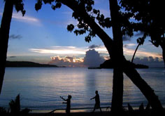
, Guam") Evening at Tumon Bay (Tomhom), Guam, Tumon is the center of Guam's tourist industry. Image: youkaine Travel and Tour Consumer Information
Destination Guam - Travel and Tour GuidesDiscover Guam: Ritidian Point (northernmost point of the island, part of the Guam National Wildlife Refuge); Guam National Wildlife Refuge (latte stones and other cultural sites like a newly rediscovered ancient village); Cocos Island (uninhabited island with a day resort within the Merizo Barrier Reef); Mount Lamlam (highest peak on Guam, some say the highest mountain on Earth measured from the deep of the Mariana Trench); Latte Stone Park () Find accommodation, hotels, attractions, events, tourist boards, cruising, diving, tours and much more. Welcome to Guam The Guam Visitors Bureau's Official WebSite. Guam Guide Online directory to the Pacific island of Guam. Bisita Guam Visit Guam, guided by a native Chamorro. What's It Like to Live on Guam? A guide to Guam. Guam-OnLine.Com A guide to the US Pacific Island Territory of Guam. Visit Guam Visit Guam. Clip: Guam Visitors Bureau |
 Alupang Rock © e-pixs Guam - Sam Ross |
EducationGuam Community College GCC offers Associate Degrees and Certificates in more than 50 areas of study. University of Guam The University of Guam is the major institution of higher education in the Western Pacific. |
Environment & NatureGuam Environmental Protection Agency Guam's EPA provides environmental information. Guam Department of Parks and Recreation Site with less information about the department. South Pacific Regional Environment Programme (SPREP) The Pacific region's major intergovernmental organization charged with protecting and managing the environment and natural resources. |
HistoryChamorro History History of Guam's Chamoru Nation. History of Guam Guam's History from Pre-Contact Period until today. Notable History Of Events on Guam Overview on Guam's History and its role in various wars. War in the Pacific The role of Guam in the War in the Pacific. |
Sources and additional Information on Guam
|
 |
Other Political divisions of the United States: US States | American Samoa | Northern Mariana Island | Puerto Rico | US Virgin Islands |
One World - Nations Online .:. let's care for this planet Promote that every nation assumes responsibility for our world. Nations Online Project is made to improve cross-cultural understanding and global awareness. More signal - less NOISE |
| Site Map
| Information Sources | Disclaimer | Copyright © 1998-2024:: nationsonline.org |