Nations Online
All Countries in the World
Nations Online All Countries in the World | |
Home  |
___ Satellite View and Map of Germany (Deutschland) |
About Germany Map is showing Germany. The country in central Europe is bounded by the Baltic Sea, the North sea and Denmark in north, by the Netherlands, Belgium, Luxembourg, and France in west, Switzerland and Austria in south, the Czech Republic and Poland in east, and it shares maritime borders with Sweden, and the United Kingdom. Map is showing Germany. The country in central Europe is bounded by the Baltic Sea, the North sea and Denmark in north, by the Netherlands, Belgium, Luxembourg, and France in west, Switzerland and Austria in south, the Czech Republic and Poland in east, and it shares maritime borders with Sweden, and the United Kingdom. 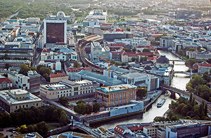 Berlin seen from the TV-tower, Alexanderplatz in direction of the Reichstag building (in background left), the seat of Germany's parliament. Image: nationsonline.org With an area of 357,022 km² Germany is the seventh largest country by area in Europe, compared it is about two-thirds the size of France, or slightly smaller than the U.S. state of Montana. Germany has a population of 80.8 million people (2015), making it the most populous country in Europe. Official language is German. Map is showing Germany with administrative boundaries of the German states (Bundesländer), state capitals, major cities, towns, expressways, main roads and streets. To find a location use the form below. To seejust the map click on the "Map" button |
|
| To find a location type: street or place, city, optional: state, country. |
Local Time Germany:
Thursday-April-25 10:44
Standard Time Zone (CET): UTC/GMT +1 hourCEST (Daylight Saving Time) in use from end of March until end of October. Time zone offset: UTC/GMT +2 hours |
|
φ Latitude, λ Longitude (of Map center; move the map to see coordinates): , |
||||||||||||||
| Google Earth: Searchable map/satellite view of Germany (Federal State of Germany). | Bookmark/share this page |
|||||||||||||
| More about Germany: Landmarks: German Cities: Country: Continent: |
Weather Conditions Berlin:
Weather Conditions Munich:
Weather Conditions Frankfurt:
|
Explore more:
Related Consumer Information:
|
||||||||||||
Major Cities in Western Europe Amsterdam, Bern, Brussels, Luxembourg (City), Monaco, Nice, Paris, Rotterdam, The Hague, Vaduz, Vienna (Wien), Zurich Searchable Maps of other Countries in Western Europe: Austria | Belgium | France | Liechtenstein | Luxembourg | Monaco | Netherlands | Switzerland Political Maps of other Countries in Western Europe: Austria Map | Belgium Map | France Map | Netherlands Map | Switzerland Map |
||
Map Help [ show ] |
||
One World - Nations Online .:. let's care for this planet Promote that every nation assumes responsibility for our world. Nations Online Project is made to improve cross-cultural understanding and global awareness. More signal - less NOISE |
| Site Map
| Information Sources | Disclaimer | Copyright © 1998-2023 :: nationsonline.org |


