Nations Online
All Countries in the World
Nations Online All Countries in the World | |
Home  |
___ Satellite View and Map of the City of Saarbrücken, Germany |
About Saarbrücken Satellite view is showing Saarbrücken, largest city and the capital city of Saarland, the smallest (except for the city states) of the 16 German Federal States. The city is located at the Saar river in south west Germany close to the border to France. Satellite view is showing Saarbrücken, largest city and the capital city of Saarland, the smallest (except for the city states) of the 16 German Federal States. The city is located at the Saar river in south west Germany close to the border to France. In the last two centuries Saarbrücken was the industrial and transport center of a great coal-mining area, today it's a university, trade fair and conference city, evolving to a center of service, science, research and modern technology. Saarbrücken has a population of 180,000 inhabitants. Spoken languages are German, Rhine Franconian, a German dialect, and French. Zoom in to see Saarbrücker Schloss (Saarbrücken castle) a baroque castle. The Map shows a city map of Saarbrücken with expressways, main roads and streets, zoom out to find the location of Saarbrücken airport (IATA code: SCN) located about 5 km (3 mi) east of the city. |
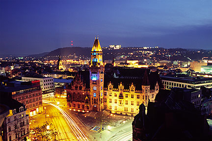 Saarbrücken Rathaus (city hall) Image: Dirk Weishaar |
| To find a location type: street or place, city, optional: state, country. |
Local Time Saarbruecken:
Thursday-May-2 00:02
Standard Time Zone (CET): UTC/GMT +1 hourCEST (Daylight Saving Time) in use from end of March until end of October: time zone offset: UTC/GMT +2 hours |
|
φ Latitude, λ Longitude (of Map center; move the map to see coordinates): , |
||||||
| Google Earth: Searchable map and satellite view of Saarbrücken, Saarland, Germany. |
Bookmark/share this page |
|||||
| City Coordinates: 49°14′0″N 7°0′0″E |
||||||
| More about Germany: Landmarks: Searchable map/satellite view of some major cities in Germany: Berlin, Bremen, Dresden, Düsseldorf, Erfurt, Frankfurt, Hamburg, Hannover, Kiel, Köln (Cologne), Magdeburg, Mainz, München (Munich), Potsdam, Schwerin, Stuttgart, Wiesbaden Bundesland (State): Country: Continent: External Links Stadt Saarbrücken The official web site of the city of Saarbrücken provides also tourist information. Wikipedia: Saarbrücken Wikipedia article about Saarbrücken. |
Current Weather Conditions Saarbrücken:
|
Explore more:
Related Consumer Information:
|
||||
| Countries and Territories of Europe |
Map Help [ show ] |
One World - Nations Online .:. let's care for this planet Promote that every nation assumes responsibility for our world. Nations Online Project is made to improve cross-cultural understanding and global awareness. More signal - less NOISE |
| Site Map
| Information Sources | Disclaimer | Copyright © 1998-2023 :: nationsonline.org |


