Nations Online
All Countries in the World
|
One Planet Nations Online All Countries in the World | |
Home  |
___ Satellite View and Map of the City State of Hamburg (Germany) |
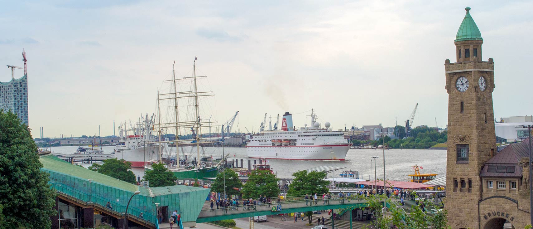
 Port of Hamburg at St. Pauli Landungsbrücken on the banks of the Elbe river, cruise ship MS Deutschland in center. Image: kk nationsonline.org |
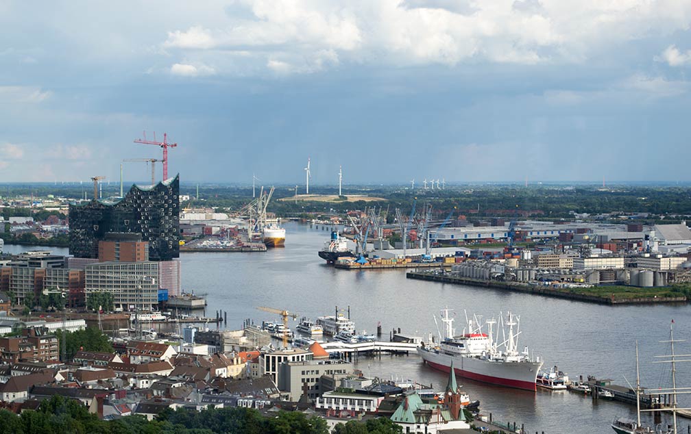
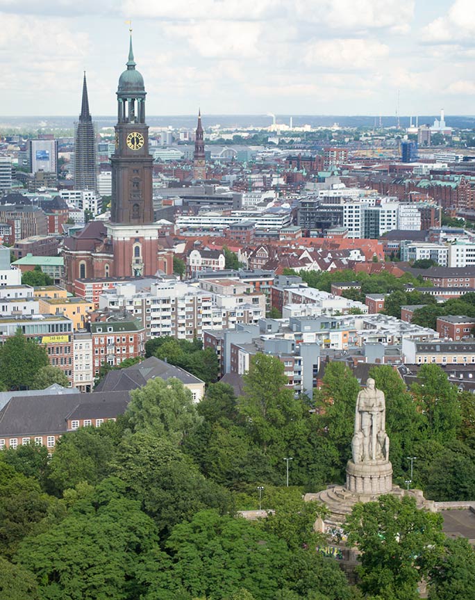
About Hamburg View from Tanzende Türme (Dancing Towers) of the port of Hamburg with Elbphilharmonie, Hamburg's landmark concert venue overlooking the harbor to the left. Image: kk nationsonline.org Germany's second largest city is situated in central north of the country where the Elbe meets with the Alster and the Bille rivers, about 100 km by ship, south east of the Elbe River's mouth on the North Sea. In the 9th century the location was a mission settlement to convert the Saxons to Christianity. Some centuries later, according to Hamburg's citizens, in 1189, Holy Roman Emperor Frederick I (Emperor Barbarossa) founded the port (it was actually a medieval fraud), anyway, the city became soon the most important trading center in Europe. In the Middle Ages the city became a member in the Hanseatic League, the commercial and defensive confederation of merchant guilds and their market towns.  St. Michaelis' Church with Bismarck Monument in foreground, view from 'The Dancing Towers', St. Pauli, Hamburg. Image: kk nationsonline.org Hamburg has a population of 1.78 million inhabitants (in 2015), more than 5 million people live and work in the Hamburg Metropolitan Region. The city is home to the Universität Hamburg (University of Hamburg), the largest institution for research and education in Northern Germany. The headquarters of Airbus Germany is located in Hamburg, the city is also a leading media location in Germany, Der Spiegel, Stern (Gruner und Jahr), Die Zeit, and many other German newspapers, magazines and books are published in Hamburg. Hamburg points of interest (the city's top sights) The Reeperbahn in the heart of the city, a street and a famous entertainment and red-light district with a long history. Kunsthalle Hamburg, large art museum, its collections covers more than seven centuries of European art. Elbphilharmonie, the city's new philharmonics and one of the largest and most acoustically advanced concert halls in the world. Internationales Maritimes Museum in the HafenCity, meet the history of ships and sea navigation.  Ad for a Carl Hagenbeck show (1886). Image: Adolph Friedländer The century-old Speicherstadt, the world's largest contiguous used warehouse complex, Speicherstadt and Kontorhaus are a UNESCO World Heritage Site. Jungfernstieg, the city's famous boulevard along Binnenalster, in 1838 Jungfernstieg became Germany's first street to be asphalt paved. Außenalster, and Binnenalster, two artificial city lakes used for recreation. Port of Hamburg, if you like ports, this is the place to be, around 9,000 ship calls per year, almost 300 berths and a total of 43 kilometers of quay for seagoing vessels. Fans of model railways will be in heaven at Miniatur Wunderland (Miniature Wonderland), the largest of its kind in the world. The Emigration Museum documents the story of the millions of European emigrants who are about to start their journey to the New World 120 years ago. Planten un Blomen (plants and flowers), inner-city urban park with occasional water-light concerts, public theater and music performances, within the park is also the Old Botanical Garden of Hamburg. Tierpark Hagenbeck, is Hamburg's zoo, founded by a fishmonger in the beginning of the 20th century, it was the first zoo in the world to use open enclosures surrounded by moats to present the animals to the public. Shopping Hanseatic Style Between Central Station and Hamburger Rathaus (city hall) you will find the household name department stores and shopping malls selling the usual high fashion brands on Mönckebergstraße, Spitalerstraße, Levantehaus, and the Europa Passage. Recent Events In 2017 Hamburg is host to the twelfth meeting of the Group of Twenty (G20 summit) on the 7th and 8th of July, 2017. The summit is accompanied by many G20 protesters and as many German riot police. The map shows a city map of Hamburg, with expressways (Autobahn), main roads and streets, zoom out to find the location of Hamburg Fuhlsbüttel Airport (IATA code: HAM) about 8.5 km (5.3 mi) north of the city center. Included on the map is the regional border of Hamburg (the red dashed line around the city). To find a location use the form below. |
|
| To find a location type: street or place, city, optional: state, country. |
Local Time Hamburg:
Thursday-April-25 23:05
Standard Time Zone (CET): UTC/GMT +1 hourCEST (Daylight Saving Time) in use from end of March until end of October. Time zone offset: UTC/GMT +2 hours |
|
φ Latitude, λ Longitude (of Map center; move the map to see coordinates): , |
||||||
| Google Maps: Searchable map/satellite view of the City and Federal State of Germany, Hamburg. City Coordinates: 53°33′55″N 10°00′05″E |
Bookmark/share this page
|
|||||
| More about Germany: Landmarks: Searchable map/satellite view of some major cities in Germany: Berlin, Bremen, Dresden, Düsseldorf, Erfurt, Frankfurt, Hannover, Kiel, Köln (Cologne), Magdeburg, Mainz, München (Munich), Potsdam, Saarbrücken, Schwerin, Stuttgart, Wiesbaden State: Country: Continent: |
Hamburg Weather Conditions: External Links Hamburg Freie und Hansestadt Hamburg; the Citystate and State Capital's official website. Wikipedia: Hamburg |
Explore more:
Related Consumer Information:
|
||||
Europe's Alpha Cities Tour: Rome - Zürich - Madrid - Paris - Amsterdam London - Stockholm - Berlin - Prague - Vienna - Istanbul Other Major Cities in Western Europe Bern, Bordeaux, Brussels, Cannes, Cologne, Den Hague, Dresden, Düsseldorf, Frankfurt, Geneva, Luxembourg (City), Lyon, München, Monaco, Nice, Rotterdam, Strasbourg, Stuttgart, Toulouse, Vaduz |
Map Help [ show ]  |
One World - Nations Online .:. let's care for this planet Promote that every nation assumes responsibility for our world. Nations Online Project is made to improve cross-cultural understanding and global awareness. More signal - less NOISE |
| Site Map
| Information Sources | Disclaimer | Copyright © 1998-2023 :: nationsonline.org |