Nations Online
All Countries in the World
Nations Online All Countries in the World | |
Home  |
|
___ Satellite View and Map of the City of Düsseldorf, Germany |
|
About Duesseldorf Satellite view is showing Duesseldorf, the capital city of the German Federal State of Nordrhein-Westfalen (North Rhine-Westphalia). Satellite view is showing Duesseldorf, the capital city of the German Federal State of Nordrhein-Westfalen (North Rhine-Westphalia). 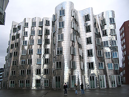 Neuer Zollhof in Düsseldorf, the building was designed by famous architect Frank Gehry. He also created the Guggenheim Museum of Bilbao. Photo: Sami Cetinkaya Duesseldorf has a population of almost 600 000 inhabitants. The city is famous for its fashion events and for its high-end shopping facilities especially on Königsallee (Kö). Just zoom in to see the Parliament building of North Rhine-Westphalia state and the Rheinturm (Rhine Tower) a 240.5 m (790 ft) tall concrete telecommunications and observation tower. The Map shows a city map of Duesseldorf with expressways, main roads and streets, zoom out to find Düsseldorf International Airport (IATA code: DUS) the third largest airport in Germany, located about 9 km (5.6 mi) north from the city center. To find a location use the form below. To see just the map click on the "Map" button. |
|
| To find a location type: street or place, city, optional: state, country. |
Local Time Duesseldorf:
Friday-April-26 08:51
Standard Time Zone (CET): UTC/GMT +1 hourCEST (Daylight Saving Time) in use from end of March until end of October. Time zone offset: UTC/GMT +2 hours |
 Map of Bavaria Map of Bavaria |
 Map of Berlin Map of Berlin |
 Map of Brandenburg Map of Brandenburg |
|
 Map of Bremen Map of Bremen |
 Map of Hamburg Map of Hamburg |
 Map of Hesse Map of Hesse |
 Map of Lower Saxony Map of Lower Saxony |
 Map of Mecklenburg-Western Pomerania Map of Mecklenburg-Western Pomerania |
 Map of North Rhine-Westphalia Map of North Rhine-Westphalia |
 Map of Rhineland-Palatinate Map of Rhineland-Palatinate |
 Map of Saarland Map of Saarland |
 Map of Saxony Map of Saxony |
 Map of Saxony-Anhalt Map of Saxony-Anhalt |
 Map of Schleswig-Holstein Map of Schleswig-Holstein |
 Map of Thuringia Map of Thuringia |
Europe's Alpha Cities Tour: Rome - Zürich - Madrid - Paris - Amsterdam London - Stockholm - Berlin - Prague - Vienna - Istanbul Other Major Cities in Western Europe Bern, Bordeaux, Brussels, Cannes, Cologne, Den Hague, Dresden, Frankfurt, Geneva, Hamburg, Luxembourg (City), Lyon, München, Monaco, Nice, Rotterdam, Strasbourg, Stuttgart, Toulouse, Vaduz |
||
Map Help [ show ] |
||
One World - Nations Online .:. let's care for this planet Promote that every nation assumes responsibility for our world. Nations Online Project is made to improve cross-cultural understanding and global awareness. More signal - less NOISE |
| Site Map
| Information Sources | Disclaimer | Copyright © 1998-2023 :: nationsonline.org |

