Nations Online
All Countries in the World
Nations Online All Countries in the World | |
Home  |
___ Satellite View and Map of the City of Bremen, Germany) |
Searchable Map of Bremen using Google Earth Data Satellite view is showing the region of the port city of Bremen, the Hanseatic city is situated in northwestern Germany along the Weser River about 60 km (37 mi) south from the North Sea. Satellite view is showing the region of the port city of Bremen, the Hanseatic city is situated in northwestern Germany along the Weser River about 60 km (37 mi) south from the North Sea.Bremen, together with the City of Bremerhaven which is located north of Bremen at the coast of the North Sea, is one of the 16 Federal States of Germany. 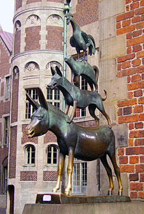 Gerhard Marcks's bronze sculpture of the Bremer Stadtmusikanten (Town Musicians) of the Grimm Brothers' fairy tale. The city of Bremen lies within the German Federal State of Lower-Saxony, it has a city population of about 550,000 inhabitants, the population of the Land Bremen (state) is about 664,000 inhabitants. The Map shows a city map of Bremen with expressways, main roads and streets, and the location of Bremen Airport (IATA code: BRE) 3.5 km (2.2 mi) south of the city. Zoom out to see the borders of the city-state, which includes the city of Bremerhaven to the north. To find a location use the form below. To see just the map click on the "Map" button. |
|
| To find a location type: street or place, city, optional: state, country. |
Local Time Bremen:
Thursday-May-2 05:54
Standard Time Zone (CET): UTC/GMT +1 hourCEST (Daylight Saving Time) in use from end of March until end of October. Time zone offset: UTC/GMT +2 hours |
|
φ Latitude, λ Longitude (of Map center; move the map to see coordinates): , |
||||||
| Google Maps: Searchable Map/Satellite view of the City and Federal State of Germany, Bremen. |
Bookmark/share this page |
|||||
| City Coordinates: 53°4′33″N 8°48′27″E |
||||||
| More about Germany: Landmarks: Searchable map/satellite view of some major cities in Germany: Berlin, Dresden, Düsseldorf, Erfurt, Frankfurt, Hamburg, Hannover, Kiel, Köln (Cologne), Magdeburg, Mainz, München (Munich), Potsdam, Saarbrücken, Schwerin, Stuttgart, Wiesbaden Bremen State (Land Bremen): Country: Continent: |
Current Weather Conditions Bremen:
External Links: Bremen Official website of Freie Hansestadt Bremen (Free Hanseatic City of Bremen) Bremen - Live it! Bremen's tourism website. Bremen Airport Wikipedia: Bremen Wikipedia article about Bremen. |
Explore more:
Related Consumer Information:
|
||||
Countries and Territories of Europe Searchable Maps of other Countries in Western Europe: Austria | Belgium | France | Liechtenstein | Luxembourg | Monaco | Netherlands | Switzerland |
Map Help [ show ] |
One World - Nations Online .:. let's care for this planet Promote that every nation assumes responsibility for our world. Nations Online Project is made to improve cross-cultural understanding and global awareness. More signal - less NOISE |
| Site Map
| Information Sources | Disclaimer | Copyright © 1998-2023 :: nationsonline.org |


 Map of Bremen


