Nations Online
All Countries in the World
Nations Online All Countries in the World | |
Home  |
___ Satellite View and Map of Mecklenburg-Vorpommern (Mecklenburg-Western Pomerania - Germany) |
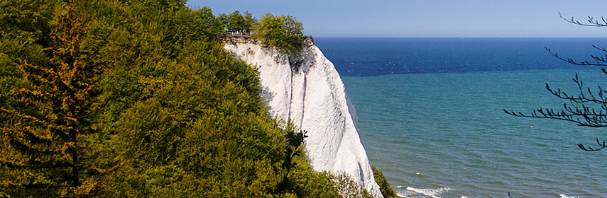 White Cliffs on the island of Rügen (Jasmund National Park - Königsstuhl), Mecklenburg-Vorpommern - Image: pe-sa |
About Mecklenburg-Vorpommern The Map shows the area of the Federal State of Mecklenburg-Vorpommern, a German 'Bundesland', located in the northeastern part of the country, bordered by the Baltic Sea (in German: Ostsee) to the north, Schleswig-Holstein to the west, Lower Saxony to the southwest, Brandenburg to the south, and it shares international borders with Poland to the east. The Map shows the area of the Federal State of Mecklenburg-Vorpommern, a German 'Bundesland', located in the northeastern part of the country, bordered by the Baltic Sea (in German: Ostsee) to the north, Schleswig-Holstein to the west, Lower Saxony to the southwest, Brandenburg to the south, and it shares international borders with Poland to the east.State capital is Schwerin, major cities are the Baltic Sea port of Rostock, Neubrandenburg, Greifswald, and the hanseatic cities of Stralsund and Wismar, the medieval towns are a UNESCO World Heritage Site Mecklenburg-Western Pomerania has a population of about 1.6 million inhabitants (mid 2014). In the basic setting of the map you see Mecklenburg-Western Pomerania with major cities, expressways (Autobahn) and main roads. Included on the map are the regional borders (Landesgrenze) of Mecklenburg-Western Pomerania (the red dashed lines, the black line represents the national border). To find a location use the form below. |
|
| To find a location type: street or place, city, optional: state, country. |
Local Time Germany:
Wednsday-May-1 12:27
Standard Time Zone: Central European Time (CET): UTC/GMT +1 hourCEST (Daylight Saving Time) in use from end of March until end of October. Time zone offset: UTC/GMT +2 hours |
|
φ Latitude, λ Longitude (of Map center; move the map to see coordinates): , |
||||||
| Google Maps: Searchable Map/Satellite view of the Federal State of Germany: Mecklenburg-Western Pomerania. |
Bookmark/share this page |
|||||
| More about Germany: Landmarks: German Cities (the Big five): Other major cities in Germany: Bremen, Dresden, Erfurt, Hannover, Kiel, Magdeburg, Mainz, Potsdam, Saarbrücken, Schwerin, Stuttgart, Wiesbaden Bundesland (State): Country: Continent: |
Current Weather Conditions Mecklenburg-Vorpommern:
External Links Mecklenburg-Vorpommern The authorized regional information system for Mecklenburg-Western Pomerania. Wikipedia: Mecklenburg-Vorpommern |
Explore more:
Related Consumer Information:
|
||||
Countries and Territories of Europe Searchable Maps of other Countries in Western Europe: Austria | Belgium | France | Liechtenstein | Luxembourg | Monaco | Netherlands | Switzerland |
Map Help [ show ] |
One World - Nations Online .:. let's care for this planet Promote that every nation assumes responsibility for our world. Nations Online Project is made to improve cross-cultural understanding and global awareness. More signal - less NOISE |
| Site Map
| Information Sources | Disclaimer | Copyright © 1998-2023 :: nationsonline.org |


 Map of Mecklenburg-Western Pomerania


