Nations Online
All Countries in the World
Nations Online All Countries in the World | |
Home  |
___ Satellite View and Map of the City of Kiel, Germany |
 Windjammerparade at the Kieler Woche (Kiel Week), the biggest sailing event in the world. Image: Arne List |
About Kiel Satellite view is showing Kiel, major port and the capital of Schleswig-Holstein, it is the most populous city in this German Federal State (in German: Bundesland). Satellite view is showing Kiel, major port and the capital of Schleswig-Holstein, it is the most populous city in this German Federal State (in German: Bundesland).The city is located in the north of Germany on the southwestern shore of the Baltic Sea at the Kiel Fjord (German: Kieler Förde), about 90 km north of Hamburg. 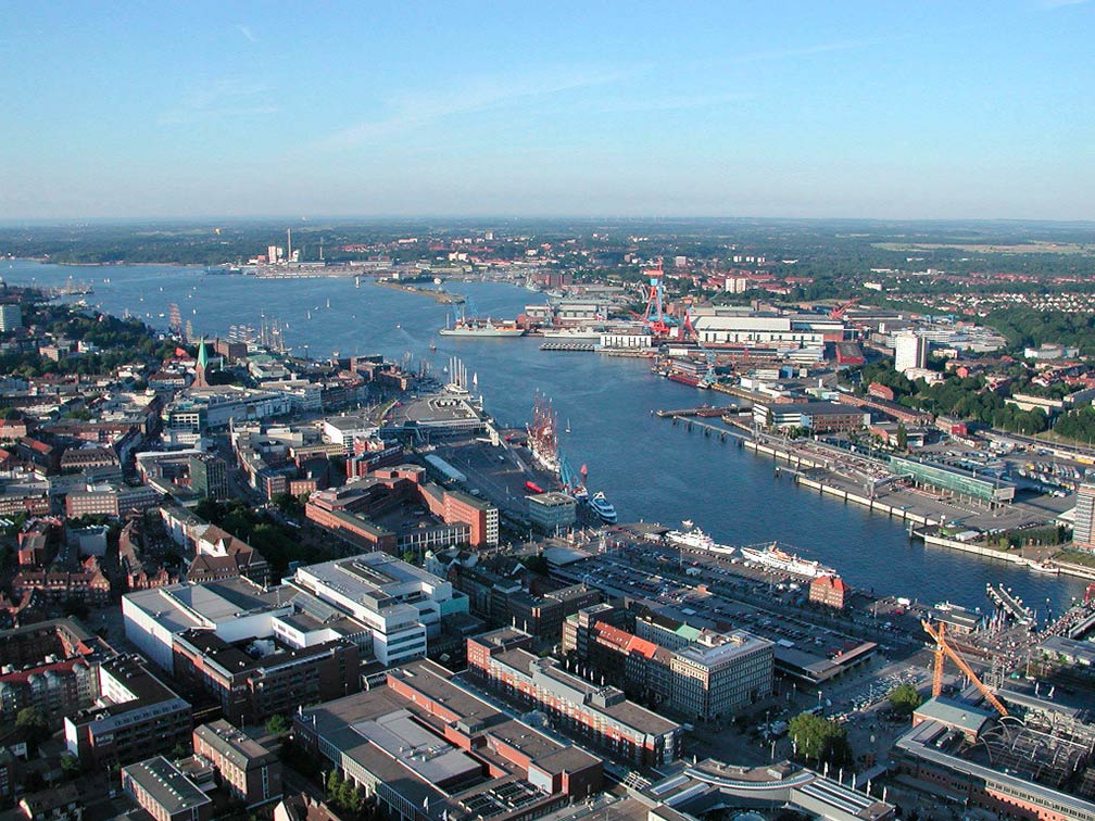 The port of Kiel, one of the major ports of the German Navy, located at the Kiel Fjord (Kieler Förde) a 17 km (11 mi) long inlet of the Baltic Sea. Image: Klaas Ole Kürtz The city calls itself the world capital of sailing, the Kieler Woche (Kiel Week), the biggest sailing event in the world takes place in Kiel at the end of June every year. Kiel is also one of Germany's main naval bases. The city is connected to the cross-European motorway A7 (Bundesautobahn) and is linked to the ICE/IC network of the German Rail. Kiel is a significant port for passenger and cargo shipping from Germany to Scandinavia, the Baltic States, and Russia. Passenger ferries operate from and to Gothenburg in Sweden, Oslo in Norway, and Klaipėda in Lithuania. Close to the city at Kiel-Holtenau is one of the entrances of the Kiel Canal (German: Nord-Ostsee-Kanal), a 100 km (61 mi) long artificial canal in Schleswig-Holstein that links the Baltic Sea with the North Sea. Kiel is seat of the University of Kiel (Christian-Albrechts-Universität, established in 1665), the largest, oldest, and most prestigious university in Schleswig-Holstein. The Map shows a city map of Kiel with expressways, main roads and streets, Kiel's small airport, Kiel-Holtenau is situated about 8.3 km (5.2 mi) north of the city. |
| To find a location type: street or place, city, optional: state, country. |
|
φ Latitude, λ Longitude (of Map center; move the map to see coordinates): , |
||||||
| Google Earth: Searchable map and satellite view of Kiel, Schleswig-Holstein, Germany. City Coordinates: 54°19′31″N 10°8′26″E |
Bookmark/share this page |
|||||
| More about Germany: Landmarks: Searchable map/satellite view of some major cities in Germany: Berlin, Bremen, Dresden, Düsseldorf, Erfurt, Frankfurt, Hamburg, Hannover, Köln (Cologne), Magdeburg, Mainz, München (Munich), Potsdam, Saarbrücken, Schwerin, Stuttgart, Wiesbaden Bundesland (State): Country: Continent: |
Weather Conditions Kiel:
External Links: Stadt Kiel Official web site of the city of Kiel. Kieler Woche The biggest sailing event in the world. Kieler Nachrichten Kieler Newspaper online (in German) Wikipedia: Kiel Wikipedia article about Kiel |
Related Consumer Information:
|
||||
| Major Cities in Northern Europe Belfast | Cardiff | Copenhagen | Dublin | Edinburgh | Glasgow | Helsinki | London | Moscow | Nuuk | Oslo Reykjavik | Riga | Saint Petersburg | Stockholm | Tallinn | Vilnius Countries and Territories of Europe |
Map Help [ show ] |
One World - Nations Online .:. let's care for this planet Promote that every nation assumes responsibility for our world. Nations Online Project is made to improve cross-cultural understanding and global awareness. More signal - less NOISE |
| Site Map
| Information Sources | Disclaimer | Copyright © 1998-2023 :: nationsonline.org |


