Nations Online
All Countries in the World
Nations Online All Countries in the World | |
Home  |
___ Satellite View and Map of the City of Mainz, Germany |
About Mainz Satellite view is showing Mainz (eng.: Mayence), the capital city of German Federal State of Rhineland-Palatinate (Rheinland-Pfalz). Satellite view is showing Mainz (eng.: Mayence), the capital city of German Federal State of Rhineland-Palatinate (Rheinland-Pfalz). 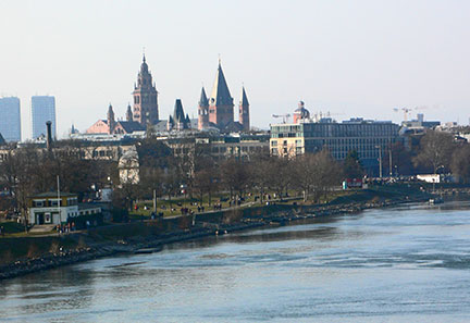 Mainz skyline with cathedral (Mainzer Dom), seen from the south Railway Bridge over the Rhine river. Image: J. Pense Mainz is one of the centers of the German wine economy. The city is also known for its yearly celebration of one of Germany's largest Carnivals, the 'Mainzer Fastnacht'. The city is also the birthplace of modern book-making. Johannes Gutenberg was born in Mainz at the end of the 14th century. His invention of the printing press revolutionized printing, it became the first "mass production" of print products like books. Just zoom in (+) to see Mainz Cathedral and the Gutenberg Museum in the center of the city. The Map shows a city map of Mainz with expressways, main roads and streets. Zoom out to find the location of the nearest airport to Mainz, Frankfurt International Airport (IATA Code: FRA), 31 km by road, east of the city. |
|
| To find a location type: street or place, city, optional: state, country. |
Local Time Mainz:
Thursday-May-2 21:14
Standard Time Zone (CET): UTC/GMT +1 hourCEST (Daylight Saving Time) in use from end of March until end of October. Time zone offset: UTC/GMT +2 hours |
|
φ Latitude, λ Longitude (of Map center; move the map to see coordinates): , |
||||||
| Google Earth: Searchable map and satellite view of Mainz, Rhineland-Palatinate, Germany. City Coordinates: 50°0′0″N 8°16′16″E |
Bookmark/share this page |
|||||
|
|
||||||
| More about Germany: Landmarks: Searchable map/satellite view of some major cities in Germany: Berlin, Bremen, Dresden, Düsseldorf, Erfurt, Frankfurt, Hamburg, Hannover, Kiel, Köln (Cologne), Magdeburg, München (Munich), Potsdam, Saarbrücken, Schwerin, Stuttgart, Wiesbaden Bundesland (State): Country: Continent: |
Current Weather Conditions Mainz/Wiesbaden/Hochheim a. M., Frankfurt area:
External Links Stadt Mainz Official web site of the city of Mainz. Touristik Centrale Mainz Mayence tourist information. Wikipedia: Mainz Wikipedia article about Mainz. |
Related Consumer Information:
|
||||
Europe's Alpha Cities Tour: Rome - Zürich - Madrid - Paris - Amsterdam London - Stockholm - Berlin - Prague - Vienna - Istanbul Other Major Cities in Western Europe Bern, Bordeaux, Brussels, Cannes, Cologne, Den Hague, Dresden, Düsseldorf, Frankfurt, Geneva, Hamburg, Luxembourg (City), Lyon, München, Monaco, Nice, Rotterdam, Strasbourg, Stuttgart, Toulouse, Vaduz |
One World - Nations Online .:. let's care for this planet Promote that every nation assumes responsibility for our world. Nations Online Project is made to improve cross-cultural understanding and global awareness. More signal - less NOISE |
| Site Map
| Information Sources | Disclaimer | Copyright © 1998-2023 :: nationsonline.org |


