Nations Online
All Countries in the World
Nations Online All Countries in the World | |
Home  |
___ Satellite View and Map of the City of Bern (Berne, Berna, Bärn) |
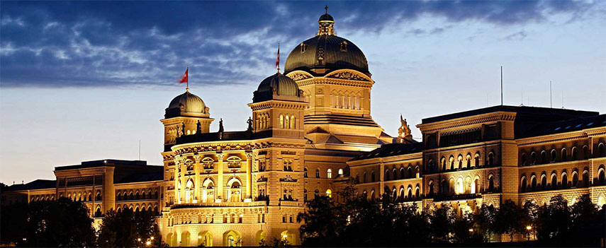 Bern House of Parliament. The Parliament Building is the seat of the Swiss government (Federal Council) and the parliament (National Council and Council of States). Construction on the Parliament Building (west wing) started in 1852. The east wing, mirroring the west wing, was added in 1884. Image: © City of Bern |
About Bern Satellite view is showing the Federal City of Berne, and de facto capital of Satellite view is showing the Federal City of Berne, and de facto capital of The city is situated on the Swiss plateau between the Jura and the Alps, approximately in the center of the country surrounded by the Aare river. 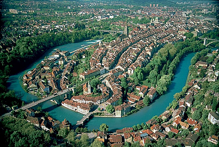 Bern at the Aare river from above. The official language of Berne is German, the local Swiss German dialect is Bernese German, spoken by most of the inhabitants. The Old Town of Berne Just zoom (+) in to see Bern Bundeshaus, the Federal Palace of Switzerland, it houses the Swiss Federal Assembly and the Swiss Federal Council. Bern Points of Interest: Some other attractions in the city are, the Bern Münster, the Cathedral is the city's most impressive example of Late Gothic architecture, its construction began in 1421. The Historical Museum of Bern (houses also the Einstein Museum), the Swiss Alpine Museum, a platform for Alpine themes, and the Paul Klee Center which features about 40 percent of Paul Klee’s entire work. The map shows a city map of Bern with expressways, main roads and streets, zoom out to find the location of Airport Bern-Belp (IATA code: BRN). To find a location use the form below. To view just the map, click on the "Map" button. |
|
| To find a location type: street or place, city, optional: state, country. |
Local Time Berne:
Tuesday-June-9 05:00
Standard Time Zone (CET): UTC/GMT +1 hourCEST (Daylight Saving Time) in use from end of March until end of October. Time zone offset: UTC/GMT +2 hours |
|
φ Latitude, λ Longitude (of Map center; move the map to see coordinates): , |
||||||
| Google Earth: Searchable map/satellite view of Bern, Switzerland. City Coordinates: 46°57′N 7°27′E |
Bookmark/share this page |
|||||
| More about Switzerland: Cities: Country: Continent: |
Current Weather Conditions Bern:
External Links: Stadt Bern Official web site of the City of Berne. Bern Tourism Berne's official tourism web site. Airport Bern Flughafen Bern-Belp Wikipedia: Berne Wikipedia entry Berne |
Related Consumer Information:
|
||||
Europe's Alpha Cities Tour: Rome - Zürich - Madrid - Paris - Amsterdam London - Stockholm - Berlin - Prague - Vienna - Istanbul Other Major Cities in Western Europe Bordeaux, Brussels, Cannes, Cologne, Den Hague, Dresden, Düsseldorf, Frankfurt, Geneva, Hamburg, Luxembourg (City), Lyon, München, Monaco, Nice, Prague, Rotterdam, Strasbourg, Stuttgart, Toulouse, Vaduz, Vienna |
||||||
Map Help [ show ] |
||||||
One World - Nations Online .:. let's care for this planet Promote that every nation assumes responsibility for our world. Nations Online Project is made to improve cross-cultural understanding and global awareness. More signal - less NOISE |
| Site Map
| Information Sources | Disclaimer | Copyright © 1998-2024:: nationsonline.org |

