Nations Online
All Countries in the World
Nations Online All Countries in the World | |
Home  |
___ Satellite View and Map of the City of Hannover (Hanover), Germany |
About Hannover Satellite view is showing Hannover, the capital city of the German Federal State of Lower Saxony (Niedersachsen). The cityis located on the river Leine in northern Satellite view is showing Hannover, the capital city of the German Federal State of Lower Saxony (Niedersachsen). The cityis located on the river Leine in northern Hannover has a population of about 500,000 inhabitants, more than a million people live in the "Hannover Region". Hannover is known worldwide as the host of the Hannover Messe (Hanover Fair, the world's biggest industrial fair) and the CeBIT (the world's largest computer trade fair). The Map shows a city map of Hannover with expressways, main roads and streets, zoom out to find the location of Hannover-Langenhagen Airport (IATA code: HAJ) about 11 km (7 mi) north of Hannover's center near the town of Langenhagen. |
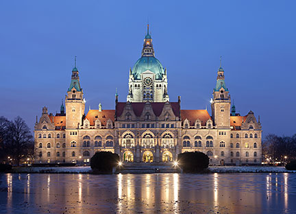 The New Town Hall (Neues Rathaus) in Maschpark (a park area) of Hannover is a landmark of the city. Image: Thomas Wolf Bookmark/share this page |
| To find a location type: street or place, city, optional: state, country. |
Local Time Hannover:
Wednsday-May-1 19:17
Standard Time Zone (CET): UTC/GMT +1 hourCEST (Daylight Saving Time) in use from end of March until end of October. Time zone offset: UTC/GMT +2 hours |
 Map of Bavaria Map of Bavaria |
 Map of Berlin Map of Berlin |
 Map of Brandenburg Map of Brandenburg |
|
 Map of Bremen Map of Bremen |
 Map of Hamburg Map of Hamburg |
 Map of Hesse Map of Hesse |
 Map of Lower Saxony Map of Lower Saxony |
 Map of Mecklenburg-Western Pomerania Map of Mecklenburg-Western Pomerania |
 Map of North Rhine-Westphalia Map of North Rhine-Westphalia |
 Map of Rhineland-Palatinate Map of Rhineland-Palatinate |
 Map of Saarland Map of Saarland |
 Map of Saxony Map of Saxony |
 Map of Saxony-Anhalt Map of Saxony-Anhalt |
 Map of Schleswig-Holstein Map of Schleswig-Holstein |
 Map of Thuringia Map of Thuringia |
| Countries and Territories of Europe | ||
Map Help [ show ] |
||
One World - Nations Online .:. let's care for this planet Promote that every nation assumes responsibility for our world. Nations Online Project is made to improve cross-cultural understanding and global awareness. More signal - less NOISE |
| Site Map
| Information Sources | Disclaimer | Copyright © 1998-2023 :: nationsonline.org |

