Nations Online
All Countries in the World
Nations Online All Countries in the World | |
Home  |
___ Satellite View and Map of Switzerland (Schweiz, Suisse, Svizzera) |
About Switzerland Map is showing Switzerland, a mountainous, landlocked country in central Europe with numerous lakes, villages and the high peaks of the Alps. Map is showing Switzerland, a mountainous, landlocked country in central Europe with numerous lakes, villages and the high peaks of the Alps.The country shares international borders with Austria, France, Germany, Italy, and Liechtenstein. The national capital is Switzerland is an international financial center and is home to the headquarters of several international organizations such as the Red Cross. Official languages are French, German, Italian, and Romansh. To find a location use the form below. To see the canton borders of Switzerland click on the "Terrain" button on the map, or go to |
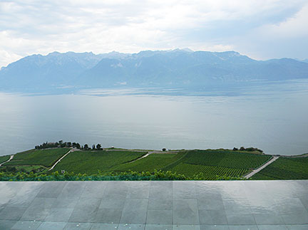 Lake Geneva (Lac Leman) near Lausanne in background the Chablais Alps in France. Image: nationsonline.org Bookmark/share this page |
| To find a location type: street or place, city, optional: state, country. |
Local Time Switzerland:
Thursday-April-25 04:56
Standard Time Zone (CET): UTC/GMT +1 hourCEST (Daylight Saving Time) in use from end of March until end of October: time zone offset: UTC/GMT +2 hours |
|
φ Latitude, λ Longitude (of Map center; move the map to see coordinates): , |
||||||
| Google Maps: Searchable map/satellite view of Switzerland. |
||||||
| More about Switzerland: Swiss Cities, information and a searchable map/satellite view of: Swiss Country: Continent: |
Current Weather Conditions Bern:
|
Related Consumer Information:
|
||||
Major Cities in Western Europe Amsterdam, Berlin, Cologne, Brussels, Frankfurt, Hamburg, Luxembourg (City), Monaco, Munich (München), Nice, Paris, Rotterdam, The Hague, Vaduz, Vienna (Wien) Searchable Maps of other Countries in Western Europe: Austria | Belgium | France | Germany | Liechtenstein | Luxembourg | Monaco | Netherlands Maps of other Countries in Western Europe: Austria Map | Belgium Map | France Map | Germany Map | Netherlands Map | Switzerland Map |
||||||
Map Help [ show ] |
||||||
One World - Nations Online .:. let's care for this planet Promote that every nation assumes responsibility for our world. Nations Online Project is made to improve cross-cultural understanding and global awareness. More signal - less NOISE |
| Site Map
| Information Sources | Disclaimer | Copyright © 1998-2023 :: nationsonline.org |

