Nations Online
All Countries in the World
Nations Online All Countries in the World | |
Home  |
___ Satellite View and Map of the Netherlands (Nederland) |
About the Netherlands Satellite view is showing the Netherlands, officially the Kingdom of the Netherlands, a nation in western Europe, bordered by the North Sea in west and north. Satellite view is showing the Netherlands, officially the Kingdom of the Netherlands, a nation in western Europe, bordered by the North Sea in west and north. Border countries are Belgium, and Germany. The country also shares maritime borders with France and the United Kingdom. Dutch Dependencies are the Caribbean islands of Aruba, and the Netherlands Antilles. European Netherlands occupies an area of 41,543 km² making it just slightly larger than Switzerland (41,285 km²) or half the size of the U.S. state of South Carolina. The Kingdom has a population of 16,785,000 (est. May 2013), capital and largest city is Amsterdam; seat of government is in the city of The Hague (Den Haag). Spoken language is Dutch (official), recognized regional languages are West Frisian (in Friesland), Papiamento (in Bonaire), and English (in Sint Eustatius and Saba). The map shows the Netherlands with with cities, towns, expressways, main roads and streets. To find a location use the form below. |
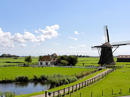 Popular view of the Netherlands, a windmill near the town of Workum in Südwest-Friesland. Image: Gouwenaar Bookmark/share this page |
| To find a location type: street or place, city, optional: state, country. |
Local Time Netherlands:
Saturday-May-4 00:03
Standard Time Zone (CET): UTC/GMT +1 hoursCEST (Daylight Saving Time) in use from end of March until end of October: time zone offset: UTC/GMT +2 hours |
|
φ Latitude, λ Longitude (of Map center; move the map to see coordinates): , |
||||||
| Google Earth: Searchable map/satellite view of the Kingdom of the Netherlands. |
||||||
| More about the Netherlands: Cities: Country: Continent: |
Current Weather Conditions Amsterdam
|
Related Consumer Information:
|
||||
Major Cities in Western Europe Berlin, Bern, Cologne, Brussels, Frankfurt, Hamburg, Luxembourg (City), Monaco, Munich (München), Nice, Paris, Rotterdam, Vaduz, Vienna (Wien), Zurich Searchable Maps of other Countries in Western Europe: Austria | Belgium | France | Germany | Liechtenstein | Luxembourg | Monaco | Switzerland Maps of other Countries in Western Europe: Austria Map | Belgium Map | France Map | Germany Map | Switzerland Map |
||||||
Map Help [ show ] |
||||||
One World - Nations Online .:. let's care for this planet Promote that every nation assumes responsibility for our world. Nations Online Project is made to improve cross-cultural understanding and global awareness. More signal - less NOISE |
| Site Map
| Information Sources | Disclaimer | Copyright © 1998-2023 :: nationsonline.org |

