
One World
Nations Online
Countries in the World
|
|
|
One World Nations Online Countries in the World | |
Home  |
___ Satellite View and Map of the City of Berlin, Germany |
 Berlin panorama seen from Berlin's former US "Spy station" on Teufelsberg (devils hill). The tower to the left is Berliner Funkturm, a former broadcasting tower constructed between 1924 and 1926, the tower to the right is Berlin TV Tower. In foreground Messe Berlin fairgrounds and the former Internationales Congress Centrum Berlin (ICC). Image: kk - nationsonline.org |
About Berlin The satellite and map view shows Berlin, largest city and the national capital of The satellite and map view shows Berlin, largest city and the national capital of 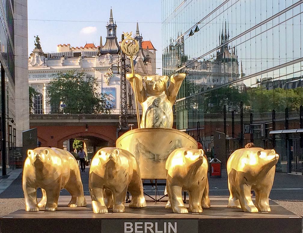 Golden Buddy Bears Quadriga. The "Berlin bear" is in the coat of arms of Berlin, the baer is also the city's mascot and many versions can be seen throughout the city. The building in the background houses the famous 'Theater des Westens' near the station of Berlin Zoologischer Garten. Image: kk - nationsonline.org Berlin has a city population of about 3.3 million inhabitants and 4.9 million people live in its metropolitan area. Just zoom in (+) to see the Berlin TV Tower (built in times of and by the German Democratic Republic, GDR). The TV tower is not to be confused with the Berliner Funkturm, constructed between 1924 and 1926 in the west part of Berlin. To find Brandenburg Gate, one of the best known symbols of Berlin, use the form below. To the north-west of the gate, at Scheidemann Straße and Platz der Republik, you see the seat of the German parliament, the Reichstag building with the glass dome adorning its roof. The Map shows a city map of Berlin with expressways, main roads and streets, zoom out to find the city's international airports: Berlin Tegel (IATA Code: TXL) and Berlin Schönefeld (IATA Code: SXF) and Berlin's new airport under construction, Berlin Brandenburg Airport (IATA Code: BER). The red dotted line around Berlin demarcates Berlin's state border. |
|
| To find a location type: street or place, city, optional: state, country. |
Local Time Berlin:
Friday-June-12 17:40
Standard Time Zone (CET): UTC/GMT +1 hourCEST (Daylight Saving Time) in use from end of March until end of October. Time zone offset: UTC/GMT +2 hours |
|
φ Latitude, λ Longitude (of Map center; move the map to see coordinates): , |
||||||
| Google Maps: Searchable map and satellite view of Berlin, Germany's capital city. City Coordinates: 52°30′2″N 13°23′56″E |
Bookmark/share this page |
|||||
|
More about Berlin and Germany: Landmarks: Satellite view and map showing Brandenburg Gate and surroundings with description. Satellite view and map showing Cologne Cathedral and surroundings with description. Searchable map/satellite view of some major cities in Germany: Bremen, Dresden, Düsseldorf, Erfurt, Frankfurt, Hamburg, Hannover, Kiel, Köln (Cologne), Magdeburg, Mainz, München (Munich), Potsdam, Saarbrücken, Schwerin, Stuttgart, Wiesbaden Berlin State (Land Berlin): Country: Continent: |
Weather Conditions Berlin:
External Links Stadt Berlin (Official web site) The Local German news. Berlin Airports Official website of Tegel International Airport (TXL), Schönefeld International Airport (SXF), and the future Airport Berlin Brandenburg International (BER). Wikipedia: Berlin |
Explore more:
Related Consumer Information:
|
||||
Europe Alpha City Tour: Rome - Zürich - Madrid - Paris - Amsterdam - London Stockholm - Berlin - Prague - Vienna - Istanbul Other Major Cities in Western Europe Bern, Bordeaux, Brussels, Cannes, Cologne, Den Hague, Dresden, Düsseldorf, Frankfurt, Geneva, Hamburg, Luxembourg (City), Lyon, München, Monaco, Nice, Rotterdam, Strasbourg, Stuttgart, Toulouse, Vaduz |
Map Help [ show ] |
One World - Nations Online .:. let's care for this planet Promote that every nation assumes responsibility for our world. Nations Online Project is made to improve cross-cultural understanding and global awareness. More signal - less NOISE |
| Site Map
| Information Sources | Disclaimer | Copyright © 1998-2024:: nationsonline.org |


 Map of Berlin


