Nations Online
All Countries in the World
Nations Online All Countries in the World | |
Home  |
___ Satellite View and Map of the City of Magdeburg, Germany |
About Magdeburg Satellite view is showing Magdeburg, the capital city of the German Federal State of Saxony-Anhalt. The city is located on the Elbe river in east Germany, about 130 km west of Berlin. Magdeburg has a population of about 230 000 inhabitants. Satellite view is showing Magdeburg, the capital city of the German Federal State of Saxony-Anhalt. The city is located on the Elbe river in east Germany, about 130 km west of Berlin. Magdeburg has a population of about 230 000 inhabitants.The city was founded by Charlemagne (Karl the Great) in 805 as Magadoburg and was for long times one of the most important medieval cities of Europe. The first Holy Roman Emperor, Otto I, lived during most of his reign in the town and he was buried in a predecessor of the Cathedral of Magdeburg, one of the oldest Gothic cathedrals in Germany. The city is connected to the federal motorways A2 and A14 and is linked to the ICE/IC network of the German Rail. Magdeburg's port at the Elbe river, connects the city with the Mittelland Canal and the Elbe-Havel Canal. Magdeburg is seat of the Otto von Guericke University and the University of Applied Sciences Magdeburg-Stendal. Just zoom in (+) to see the Cathedral of Magdeburg (Dom zu Magdeburg), the oldest Gothic cathedral in Germany. The Map shows a city map of Magdeburg with expressways, main roads and streets. |
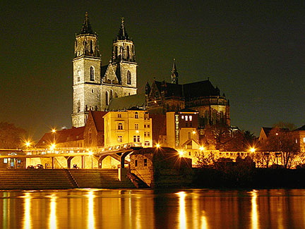 Cathedral of Magdeburg (in German: Dom zu Magdeburg) Image: Prinz Wilbert Bookmark/share this page |
| To find a location type: street or place, city, optional: state, country. |
Local Time Magdeburg:
Friday-May-3 11:24
Standard Time Zone (CET): UTC/GMT +1 hourCEST (Daylight Saving Time) in use from end of March until end of October. Time zone offset: UTC/GMT +2 hours |
|
φ Latitude, λ Longitude (of Map center; move the map to see coordinates): , |
||||||
| Google Earth: Searchable map and satellite view of Magdeburg, Saxony-Anhalt, Germany. |
||||||
| City Coordinates: 52°8′0″N 11°37′0″E |
||||||
| More about Germany: Landmarks: Searchable map/satellite view of some major cities in Germany: Berlin, Bremen, Dresden, Düsseldorf, Erfurt, Frankfurt, Hamburg, Hannover, Kiel, Köln (Cologne), Mainz, München (Munich), Potsdam, Saarbrücken, Schwerin, Stuttgart, Wiesbaden Bundesland (State): Country: Continent: |
Weather Conditions Magdeburg:
External Links: Stadt Magdeburg Official web site of the city of Magdeburg. Magdeburg Tourist-Information Magdeburg. Wikipedia: Magdeburg Wikipedia article about Magdeburg |
Related Consumer Information:
|
||||
| Countries and Territories of Europe |
Map Help [ show ] |
One World - Nations Online .:. let's care for this planet Promote that every nation assumes responsibility for our world. Nations Online Project is made to improve cross-cultural understanding and global awareness. More signal - less NOISE |
| Site Map
| Information Sources | Disclaimer | Copyright © 1998-2023 :: nationsonline.org |


