 |
|
___ Political Map of the Republic of Indonesia |
|
About Indonesia |
|
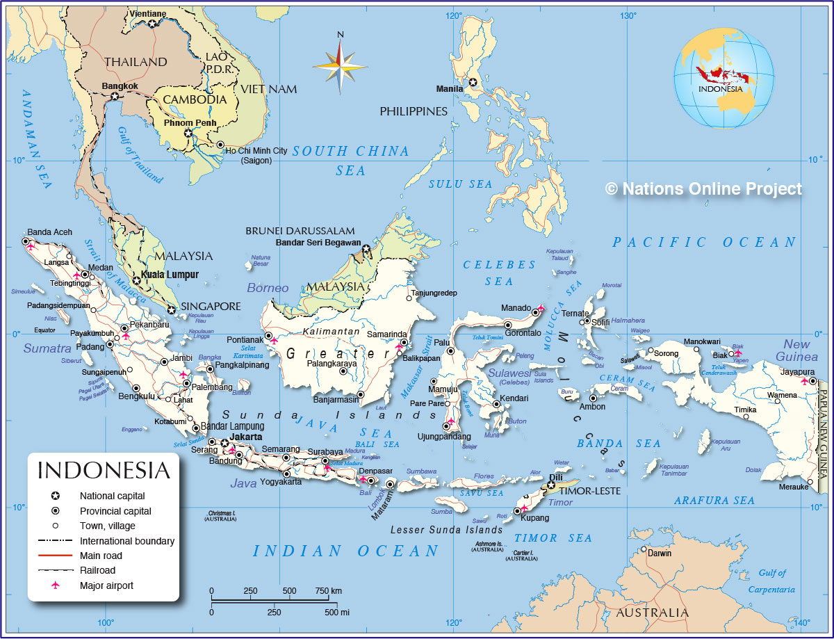
Indonesia is an island nation in Southeast Asia, between South China Sea and the Pacific Ocean (in north) and the Indian Ocean (in south). The country consists of many islands in the Malay Archipelago also known as Maritime Southeast Asia, East Indies, Indonesian archipelago, and Spices Archipelago. Map is showing the islands and surrounding countries, international borders, the national capital Jakarta, provincial capitals, major cities, main roads, railroads and major airports. Border Countries: Malaysia, Papua New Guinea, Timor-Leste. Indonesia shares maritime borders with: Australia, India, Palau, Philippines, Singapore, Thailand, and Vietnam. related countries: Netherlands, Japan, |
 Bookmark/share this page 
|
 One World - Nations Online all countries of the world |
|
|
||
 Political Map of Indonesia |
| Indonesian Islands Of the estimated 17,000 islands are about 1000 inhabited. The country is situated on diverse island groups: the Greater Sunda Islands with Indonesia's largest islands, Sumatra, Java, Borneo (partly occupied by Malaysia and Brunei) and Sulawesi (formerly known as Celebes), the chain of the Lesser Sunda Islands with Bali, Lombok, Flores, Alor, Weta, Sumbawa, Sumba, Savu, Roti, and Timor, they form a volcanic island arc. The Maluku Islands, also known as the Moluccas, they consist of over 1000 islands, the largest two are Halmahera and Seram. New Guinea, the Indonesian half of New Guinea island. |
|||||||
| Indonesian cities and towns The map shows the location of following Indonesian cities and towns: On the island of Celebes: Gorontalo, Kendari, Manado, Palu, Pare Pare, and Ujungpandang On the island of Borneo (Kalimantan): Balikpapan, Banjarmasin, Palangkaraya, Pontianak, Samarinda, Tanjungredep, Bangka, and Pangkal Pinang On the island of Sumatra: Banda Aceh, Bandar Lampung, Bengkulu, Jambi, Kotabumi, Lahat, Langsa, Medan, Padang, Padangsidempuan, Palembang, Payakumbuh, Pekanbaru, Sungaipenuh, Tebingtinggi, On the island of Java: Bandung, Jakarta, Semarang, Serang, Surabaya, and Yogyakarta On the island of Bali: Denpasar On the island of Lombok: Mataram On Timor island: Kupang and Dili (East Timor) On Halmahera island: Ternate and on the island of New Guinea: Jayapura, Manokwari, Merauke, Sorong, Timika, Wamena, On Biak island: Biak and on Ceram island: Ambon |
More about Indonesia Cities: Country: Indonesia key statistical data. Continent: |
Jakarta Weather Conditions: |
|||||
Maps of other countries in Southeast and Eastern Asia: Bangladesh Map, Bhutan Map, Cambodia Map, China Map, India Map, Japan Map Korea (North), Korea (South), Laos Map, Malaysia Map, Maldives Map, Mongolia Map, Myanmar Map Nepal Map, Pakistan Map, Philippines Map Singapore Map, Sri Lanka Map, Taiwan Map, Thailand Map, Vietnam Map | |||||||
One World - Nations Online .:. let's care for this planet Every nation is responsible for the current state of our world. |
| Site Map
| Information Sources | Disclaimer: Privacy Policy, etc. Contact: [email protected] | Copyright © 1998-2021 :: nationsonline.org |