Nations Online
All Countries in the World
Nations Online All Countries in the World | |
Home  |
___ Satellite View and Map of the City of Medan, Indonesia |
About Medan Satellite view is showing Medan, a major port, largest city and the provincial capital of North Sumatra, Satellite view is showing Medan, a major port, largest city and the provincial capital of North Sumatra, 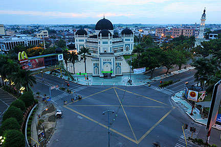 Masjid Raya Mosque, a landmark of Medan, the mosque was built between 1906 and 1909. The Great Mosque of Medan was designed by the Dutch architect Van Erp. Image: Batubara Ismail RahmatAccording to history, the city was founded at the confluence of the Deli River and the Babura River in the end of the 16th century by Guru Patimpus, a Pemena religious teacher (Guru) who later converted to Islam. The place was then known as Tanah Deli (Deli land) and the village as Medan Putri and Medan-Deli. Medan has a population of about 2.2 million inhabitants (in 2010 Official language is Indonesian (Bahasa Indonesia), but the population of Medan consists of many diverse ethnic groups: Javanese, Batak, Chinese, Mandailing, Malay, Minangkabau, Karo, and Indian, all with their own culture and language. Just zoom in (+) to see three of Medan's major tourist attractions: the Palace of the Sultan of Deli (Maimun Palace), the Great Mosque (Masjid Raya), and the historical Sri Deli Park. The city is seat of the University of North Sumatra (Universitas Sumatera Utara The map shows a city map of Medan with expressways, main roads and streets, and the location of Kualanamu International Airport To find a location use the form below. |
|
| To find a location type: street or place, city, optional: state, country. |
Local Time Indonesia:
Saturday-July-18 20:45
UTC/GMT +7 hours |
|
φ Latitude, λ Longitude (of Map center; move the map to see coordinates): , |
||||||
| Google Earth: Searchable Map and Satellite view of Medan, Indonesia. City Coordinates: 3°35′N 98°40′E |
Bookmark/share this page |
|||||
| More about Indonesia: Cities: Country: Indonesia key statistical data. Continent: External Links: Medan (official website) Wikipedia: Medan |
Current Weather Conditions Medan:
|
Related Consumer Information:
|
||||
Other Major Cities in South East Asia: Bandar Seri Begawan, Bangkok, Hanoi, Ho Chi Minh City (Saigon), Johor Bahru, Kuala Lumpur, Manila, Phnom Penh, Singapore, Vientiane, Yangon Searchable Maps of other Countries in South East Asia: Brunei, Cambodia, Laos, Malaysia, Myanmar (Burma), Philippines, Singapore, Thailand, Vietnam |
One World - Nations Online .:. let's care for this planet Promote that every nation assumes responsibility for our world. Nations Online Project is made to improve cross-cultural understanding and global awareness. More signal - less NOISE |
| Site Map
| Information Sources | Disclaimer | Copyright © 1998-2024:: nationsonline.org |
