Nations Online
All Countries in the World
Nations Online All Countries in the World | |
Home  |
___ Satellite View and Map of United Kingdom (UK) |
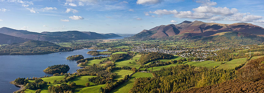 Panorama with the town of Keswick, nestled between the fells (hills) of Skiddaw and Derwentwater in the Lake District, Cumbria, England. Taken from about 3/4 of the way to the summit of Walla Crag. Image: David Iliff |
About the United Kingdom Map is showing the British Isles in north western Europe between the North Sea in east, the North Atlantic Ocean in west and the English Channel in south. It is bordered by the Republic of Ireland, and it shares maritime borders with Belgium, Denmark, France, Germany, Netherlands, Norway, and the Faroe Islands (Denmark). Map is showing the British Isles in north western Europe between the North Sea in east, the North Atlantic Ocean in west and the English Channel in south. It is bordered by the Republic of Ireland, and it shares maritime borders with Belgium, Denmark, France, Germany, Netherlands, Norway, and the Faroe Islands (Denmark).The United Kingdom, a unitary sovereign state, is made up of England, Scotland, and Wales, on the island of Great Britain, the three countries with a degree of autonomy within the UK, and Northern Ireland, the British province in the northeast of the island of Ireland. The United Kingdom occupies an area of 242,900 km² making it about half the size of Spain, or slightly smaller than the U.S. state of Oregon. UK's landscape offers quite some variety, England is mostly flat with some mountainous terrain in the Lake District, around Yorkshire Dales National Park, North York Moors National Park and the Peak District National Park. Wales is adorned with a rugged coastline, its interior topography ranges between hilly and mountainous. In the Scotland package you will find the Southern Uplands, the Central Lowlands, the Grampian Mountains, the North West Highlands, the archipelagos of the Inner and Outer Hebrides, and the Shetlands, and the Orkney Islands. Highest elevation in the UK is Ben Nevis with 1,344 m (4,409 ft), the mountain is located in the Grampian mountain range in Scotland. The longest river in the country is the River Severn with a length of about 354 km (220 mi), it runs from its source in the Hafren Forest on the slopes of the Plynlimon in Wales, through the central region of England and Wales and empties into the Bristol Channel. The United Kingdom has a population of 64.1 million people (mid-2013), capital city of England and the UK is Some of the highlights in the UK you don't want to miss when visiting: Stonehenge, Loch Ness, London Tower Bridge, and the Palace of Westminster. On the map you see the United Kingdom, with major cities, expressways and main roads. To find a location use the form below. |
|
| To find a location type: street or place, city, optional: state, country. |
Local Time United Kingdom:
Monday-August-3 07:21
Standard time zone: No UTC/GMT offsetDaylight saving time (BST) in use from end of March until end of October, time zone offset: UTC/GMT +1 hours |
One World - Nations Online .:. let's care for this planet Promote that every nation assumes responsibility for our world. Nations Online Project is made to improve cross-cultural understanding and global awareness. More signal - less NOISE |
| Site Map
| Information Sources | Disclaimer | Copyright © 1998-2024:: nationsonline.org |


