Nations Online
All Countries in the World
|
One Planet Nations Online All Countries in the World | |
Home  |
___ Satellite View and Map of Scotland (United Kingdom) |
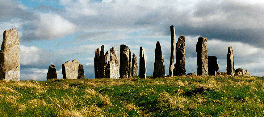
 Callanish Stones, near the village of Callanish on the Isle of Lewis (Outer Hebrides), Scotland. The stones were erected in the late Neolithic era (about 3000 years ago), numerous other ritual sites lie within a few kilometers. Image: Marta Gutowska |
About Scotland Satellite view is showing Scotland, on the northern third of the island of Great Britain, bounded by the Atlantic Ocean to the north and west and the North Sea to the east. Satellite view is showing Scotland, on the northern third of the island of Great Britain, bounded by the Atlantic Ocean to the north and west and the North Sea to the east.Capital city of Scotland is Edinburgh. Spoken languages are English (official) and the Scottish form of Gaelic. The map shows Scotland with cities, towns, expressways, main roads and streets. To find a location use the form below. To view just the map, click on the "Map" button. |
||||||
| To find a location type: street or place, city, optional: state, country. |
Local Time UK:
Thursday-April-25 02:49
Standard time zone: No UTC/GMT offsetDaylight saving time (BST) in use from end of March until end of October, time zone offset: UTC/GMT +1 hours |
|||||
|
φ Latitude, λ Longitude (of Map center; move the map to see coordinates): , |
||||||
| Google Maps: Searchable Map of Scotland (United Kingdom) |
Bookmark/share this page
|
|||||
| More about the United Kingdom: Landmarks: Information and searchable city maps: Country: Continent: |
Weather Conditions Edinburgh: External Links: City of Edinburgh City of Edinburgh Council. Edinburgh The official Tourist Board. BAA Edinburgh Official Edinburgh Airport website Wikipedia: Edinburgh Wikipedia article about Edinburgh. |
Related Consumer Information:
|
||||
Major Cities in Northern Europe Belfast | Birmingham | Cardiff | Copenhagen | Dublin | Edinburgh | Glasgow | Helsinki | Liverpool | London | Malmö Manchester | Nuuk | Oslo | Reykjavik | Riga | Saint Petersburg | Stockholm | Tallinn | Vilnius Maps of other Countries in Northern Europe Denmark Map, Estonia Map, Faroe Islands Map, Greenland Map, Iceland Map, Ireland Map, Latvia Map, Lithuania Map, Sweden Map, United Kingdom Map Interactive Maps of other countries and regions in Northern Europe: Denmark Interactive Map, Faroe Islands Interactive Map, Greenland Interactive Map, Iceland Interactive Map, Ireland Interactive Map, Latvia Interactive Map, Lithuania Interactive Map, Norway Interactive Map, Scotland Interactive Map, Sweden Interactive Map, United Kingdom Interactive Map |
||||||
Map Help [ show ]  |
||||||
One World - Nations Online .:. let's care for this planet Promote that every nation assumes responsibility for our world. Nations Online Project is made to improve cross-cultural understanding and global awareness. More signal - less NOISE |
| Site Map
| Information Sources | Disclaimer | Copyright © 1998-2023 :: nationsonline.org |