Nations Online
All Countries in the World
Nations Online All Countries in the World | |
Home  |
___ Satellite View and Map of Vietnam |
Searchable Map of Vietnam using Google Earth Data Map/Satellite view is showing Vietnam the long streched country along the eastern coast of the Indochinese Peninsula. Map/Satellite view is showing Vietnam the long streched country along the eastern coast of the Indochinese Peninsula. 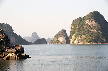 Halong Bay (Ha Long), a bay with almost 2000 islets, most of which are limestone, located in Quảng Ninh province, northern Viet Nam. Image: © Nations Online Project With an area of 331,689 km² Vietnam is about three times the size of Bulgaria or slightly larger than the U.S. state of New Mexico. Vietnam has a population of 90.7 million people (in 2014), the 13th most populous country in the world. Spoken language is Vietnamese, English is increasingly favored as a second language, and there are still people speak some French. Capital city of Vietnam is Hanoi (Ha Noi), former capital of the Republic of Vietnam and largest city is Ho Chi Minh City (also known as Saigon). The Map shows Vietnam with cities, towns, expressways, main roads and streets. To find a location like Saigon, Hanoi, Dalat, Hue or Ha Long Bay use the form below. |
|
| To find a location type: street or place, city, optional: state, country. |
Local Time Viet Nam:
Thursday-April-25 17:38
Time zone: Indochina Time (ICT) :: UTC/GMT +7 hours |
|
φ Latitude, λ Longitude (of Map center; move the map to see coordinates): , |
||||||
| Sorry! Google's pricing policy has made it impossible for us to continue showing Google Maps. We apologize for any inconvenience. Google Map: Searchable map/satellite view of Socialist Republic of Vietnam. | Bookmark/share this page |
|||||
|
|
||||||
| More about Vietnam: Cities: Country: Viet Nam key statistical data. Continent: |
Current Weather Conditions Hanoi:
|
Related Consumer Information:
|
||||
Searchable Maps of other Countries in South East Asia: Brunei, Cambodia, Indonesia, Laos, Malaysia, Myanmar (Burma), Philippines, Singapore, Thailand, Vietnam Major Cities in South East Asia: Bandar Seri Begawan, Bandung, Bangkok, Jakarta, Johor Bahru, Kuala Lumpur, Manila, Medan, Phnom Penh, Surabaya, Singapore, Vientiane, Yangon |
|||
Map Help [ show ] |
|||
One World - Nations Online .:. let's care for this planet Promote that every nation assumes responsibility for our world. Nations Online Project is made to improve cross-cultural understanding and global awareness. More signal - less NOISE |
| Site Map
| Information Sources | Disclaimer | Copyright © 1998-2023 :: nationsonline.org |

