Nations Online
All Countries in the World
Nations Online All Countries in the World | |
Home  |
___ City Map and Satellite View of Singapore |
About Singapore The Map/Satellite view is showing Singapore, the city-state situated on the southern tip of the Malay Peninsula, 142 kilometers (88 mi) north of the equator, and immediately south of Peninsular Malaysia. In south the Strait of Singapore separates the island from the Riau Archipelago (Indonesia). The Map/Satellite view is showing Singapore, the city-state situated on the southern tip of the Malay Peninsula, 142 kilometers (88 mi) north of the equator, and immediately south of Peninsular Malaysia. In south the Strait of Singapore separates the island from the Riau Archipelago (Indonesia). With an area of 718 km², Singapore is just half the size of the Faroe Islands, or slightly more than 3.5 times the size of Washington, DC. 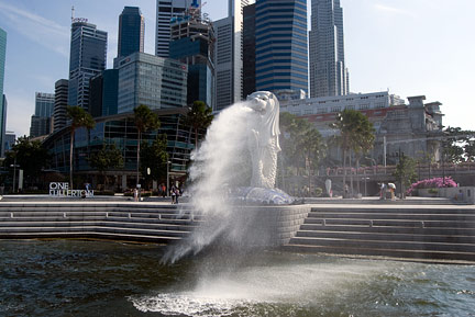 The Merlion, a mythical creature with the head of a lion and the body of a fish, is Singapore's Icon, the statue is located in front of Fullerton Hotel and Singapore's Central Business District. Image: © Nations Online Project Singapore has a population of about 5.5 million (2015). To the north within walking distance from the city state lies Johor Bahru, capital of the Malayan state of Johor and second largest city in Malaysia. The total population of the Singapore-Johor Bahru conurbation is 6.6 million. Official languages of Singapore are Malay, Mandarin and Tamil, also official language is English which is used as lingua franca between the various population groups. The Map shows a city map of Singapore with expressways, main roads and streets. Zoom out to find the location of Singapore Changi International Airport (IATA code: SIN) east of Singapore’s Central Business District. To find a location use the form below. To view the map, click on the "Map" button. |
|
| To find a location type: street or place, city, optional: state, country. |
Local Time Singapore:
Friday-April-26 15:26
UTC/GMT +8 hours |
|
φ Latitude, λ Longitude (of Map center; move the map to see coordinates): , |
||||||
| Google Earth: Searchable map/satellite view of Singapore. City Coordinates (Downtown): 1°17′N 103°50′E |
Bookmark/share this page |
|||||
| More about Singapore: City and Country: Singapore key statistical data. Border Country Malaysia: Continent: |
Weather Conditions Singapore (Changi Airport):
External Links: Singapore Official government website. Singapore Official tourism website. The Straits Times Local news. Wikipedia: Singapore Wikipedia entry Singapore. |
Explore more:
Related Consumer Information:
|
||||
Other Major Cities in South East Asia: Bandar Seri Begawan, Bandung, Bangkok, Hanoi, Ho Chi Minh City (Saigon), Jakarta, Johor Bahru, Kuala Lumpur, Manila, Medan, Phnom Penh, Surabaya, Vientiane, Yangon Searchable Maps of other Countries in South East Asia: Brunei, Cambodia, Indonesia, Laos, Malaysia, Myanmar (Burma), Philippines, Singapore, Thailand, Vietnam |
||
Map Help [ show ] |
||
One World - Nations Online .:. let's care for this planet Promote that every nation assumes responsibility for our world. Nations Online Project is made to improve cross-cultural understanding and global awareness. More signal - less NOISE |
| Site Map
| Information Sources | Disclaimer | Copyright © 1998-2023 :: nationsonline.org |

