Nations Online
All Countries in the World
Nations Online All Countries in the World | |
Home  |
___ Satellite View and Map of the City of Bandar Seri Begawan (بندر سري بڬاوان) |
About Bandar Seri Begawan Satellite view is showing Bandar Seri Begawan, the national capital and the royal town of the Sultanate of Satellite view is showing Bandar Seri Begawan, the national capital and the royal town of the Sultanate of Until 1970 the city was known as Brunei City (Bandar Brunei), the city was then renamed by the Sultan of Brunei in honor of his father. Bandar Seri Begawan is located in the north eastern part of the country on the northern bank of Brunei River (Sungai Brunei). 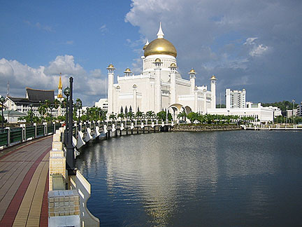 Sultan Omar Ali Saifuddien Mosque in the center of Bandar Seri Begawan. Image: Daniel Weiss About 300,000 people live in Brunei-Muara District, the north eastern corner of the country, the district is virtually the metropolitan area of Brunei City. Spoken language is Malay (Bahasa Melayu), English in use as a bridge language. Some attractions in BSB are, Sultan Omar Ali Saifuddin Mosque, considered to be one of the most beautiful mosques in South East Asia. The Islamic mosque is named after Omar Ali Saifuddien III, the 30th Sultan of Brunei. Istana Nurul Iman, the palace and the official residence of the Sultan of Brunei, it is also the seat of the Brunei government. The Brunei Museum, the national museum of the country. Jerudong Park, Brunei's amusement park opened in 1994. The city is home to the Universiti Brunei Darussalam The map shows a city map of Bandar Seri Begawan with expressways, and the location of Brunei International Airport (IATA code: BWN). To find a location use the form below. |
|
| To find a location type: street or place, city, optional: state, country. |
Local Time Bandar Seri Begawan:
Tuesday-July-7 10:00
UTC/GMT +8 hours |
|
φ Latitude, λ Longitude (of Map center; move the map to see coordinates): , |
||||||
| Google Earth: Searchable Map and Satellite view of Bandar Seri Begawan City Coordinates: 4°53′25″N 114°56′32″E |
Bookmark/share this page |
|||||
| More about Brunei: Country: Brunei key statistical data. Continent: External Links: Bandar Seri Begawan Official website of the Municipal Department Bandar Seri Begawan. Wikipedia: Bandar Seri Begawan |
Current Weather Conditions Brunei:
|
Related Consumer Information:
|
||||
Other Major Cities in South East Asia: Bandung, Bangkok, Hanoi, Ho Chi Minh City (Saigon), Jakarta, Johor Bahru, Kuala Lumpur, Manila, Medan, Phnom Penh, Singapore, Surabaya, Vientiane, Yangon Searchable Maps of other Countries in South East Asia: Brunei, Cambodia, Indonesia, Laos, Malaysia, Myanmar (Burma), Philippines, Singapore, Thailand |
||
Map Help [ show ] |
||
One World - Nations Online .:. let's care for this planet Promote that every nation assumes responsibility for our world. Nations Online Project is made to improve cross-cultural understanding and global awareness. More signal - less NOISE |
| Site Map
| Information Sources | Disclaimer | Copyright © 1998-2024:: nationsonline.org |

