
| Home |
|
|
|
___ Administrative Map of Vietnam | |
About Vietnam |
|
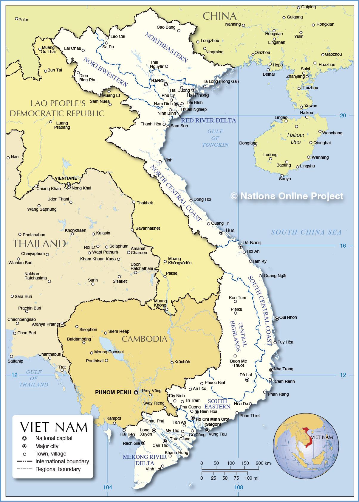
| Viet Nam is situated in Southeast Asia, it is the easternmost country on the Indochinese peninsula. The country's shape reminds of an S, it has a long coast along South China Sea, it borders China in north, and it has a long border with Laos and borders Cambodia in southwest. Vietnam shares maritime borders with Indonesia, Malaysia, Philippines, and Thailand. With an area of 331,689 km² it is about the size of Finland or slightly larger than the U.S. state of New Mexico. Vietnam has a population of about 90.7 million people (in 2014), making it number 13 on the list of the most populous countries. Spoken language is Vietnamese, English is increasingly favored as a second language, and there are still people speak some French. Map is showing Vietnam and the surrounding countries with international borders, region boundaries, the national capital Hanoi, and major cities. Administrative Regions of Viet NamVietnam is divided into 58 provinces ( in Vietnamese: tỉnh), and there are 5 centrally-controlled municipalities existing at the same level as provinces: Hanoi, Ho Chi Minh City, Can Tho, Da Nang and Hai Phong.Regions of Viet Nam:Vietnam's eight regions shown on the map are: the Northwestern Region (Tây Bắc), the Northeastern Region (Dong Bac), Greater Ha Noi/ Red River Delta (Hà Nội Kinh-Dong Bang Song Hong), North Central Coast (Bắc Trung Bộ), South Central Coast (Nam Trung Bộ), Central Highlands (Tây Nguyên), Southeastern (Đông Nam Bộ), and the Southwestern region, in the Mekong River Delta (Tây Nam Bộ-Đồng Bằng Sông Cửu Long) |
 Bookmark/share this page |
 One World - Nations Online all countries of the world |
|
|
||
 Administrative Map of Viet Nam |
|||||||
| Map shows the location of following Vietnamese cities and towns: An Loc, Bien Hoa, Buon Ma Thuot, Cam Ranh, Can Tho (largest city in the Mekong delta), Cao Bang, Chau Phu, Dalat, Da Nang, Dien Bien Phu, Dong Hoi, Go Cong, Ha Long (Hong Gai), Hai Duong, Hai Phong (3rd largest city in Vietnam), Hanoi (capital city), Ha Tien, Ho Chi Minh City (Saigon, largest city in Vietnam), Hoi An, Hòa Da, Hue, Khanh Hung, Kon Tum, Lai Chau, Lao Cai, Long Xuyen, Muong Het, My Tho, Nam Dinh, Nha Trang, Ninh Binh, Phan Rang, Phan Thiet, Phu Cuong, Phu Lý, Phuoc Binh , Pleiku, Quang Ngai, Quang Tri, Sam Son, Tam Ky, Tan An, Tay Ninh, Thanh Hóa, Thái Bình, Thái Nguyên, Thuan Nghiep, Tri Tram, Trúc Giang, Tuy Hòa, Vinh Loi, Vinh Rach Gia, and Vung Tàu. |
More about Vietnam: Cities: Country: Vietnam key statistical data. Continent: |
Current Weather Conditions Hanoi:
|
Related Consumer Information: |
||||
Maps of other countries in Southeast and Eastern Asia: Bangladesh Map, Bhutan Map, Cambodia Map, China Map, India Map, Indonesia Map, Japan Map Korea (North), Korea (South), Laos Map, Malaysia Map, Maldives Map, Mongolia Map, Myanmar Map Nepal Map, Pakistan Map, Philippines Map Singapore Map, Sri Lanka Map, Taiwan Map, Thailand Map | |||||||
One World - Nations Online .:. let's care for this planet Every nation is responsible for the current state of our world. |
| Site Map
| Information Sources | Disclaimer: Privacy Policy, etc. Contact: [email protected] | Copyright © 1998-2021 :: nationsonline.org |
