Nations Online
All Countries in the World
Nations Online All Countries in the World | |
Home  |
___ Searchable Map and Satellite view of Malaysia |
About Malaysia Map is showing Peninsular Malaysia also known as West Malaysia, south of Thailand bordering the Strait of Malacca in west, to the south is the island city state of Singapore. Map is showing Peninsular Malaysia also known as West Malaysia, south of Thailand bordering the Strait of Malacca in west, to the south is the island city state of Singapore. 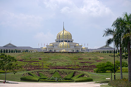 Istana Negara, or Agong's Palace, in Kuala Lumpur is the official residence of the Yang di-Pertuan Agong, Malaysia's King. Image: nationsonline.org Capital city of Malaysia is Kuala Lumpur (pop. 1.6 million). Official language is Malay. Countries with international borders to Malaysia are Brunei, Indonesia, Singapore, and Thailand. The map shows Malaysia with cities, towns, expressways, main roads and streets. Malaysian Airlines' Boeing Triple Seven en route from Kuala Lumpur to Beijing, China, disappeared in the early morning of 8th March 2014 between Malaysia and Vietnam. You will find more explanations at our MH 370 Search Area Map. |
|
| To find a location type: street or place, city, optional: state, country. |
Local Time Malaysia
Friday-June-19 16:47
Time zone: Malaysia Time (MYT) UTC/GMT +8 hours |
|
φ Latitude, λ Longitude (of Map center; move the map to see coordinates): , |
||||||
| Google Earth: Searchable Map and Satellite View of the Federation of Malaysia. | Bookmark/share this page |
|||||
|
|
||||||
| More about Malaysia: Cities: Country: Malaysia Key Statistical Data. Continent: |
Weather Conditions Kuala Lumpur:
|
Related Consumer Information:
|
||||
Searchable Maps of other Countries in South East Asia: Brunei, Cambodia, Indonesia, Laos, Malaysia, Myanmar (Burma), Philippines, Singapore, Thailand, Vietnam |
|||
Map Help [ show ] |
|||
One World - Nations Online .:. let's care for this planet Promote that every nation assumes responsibility for our world. Nations Online Project is made to improve cross-cultural understanding and global awareness. More signal - less NOISE |
| Site Map
| Information Sources | Disclaimer | Copyright © 1998-2024:: nationsonline.org |

