Nations Online
All Countries in the World
Nations Online All Countries in the World | |
Home  |
___ Searchable Map and Satellite view of the City of Johor Bahru (JB) |
About Johor Bahru Satellite view is showing Johor Bahru (also spelled Johor Baharu), second largest city in Satellite view is showing Johor Bahru (also spelled Johor Baharu), second largest city in The city is located on the southern tip of the Malay Peninsula within walking distance of Singapore that lies to the south. Johor Bahru is connected with the city-state by a causeway. Until 1855 Johor Bahru was a small fishing village, this changed when Johor's Temenggung (a noble title) established his administrative headquarters at the site. By the early 1850s, Johor was effectively under the control of the Temenggung, despite that Sultan Ali was the official ruler. 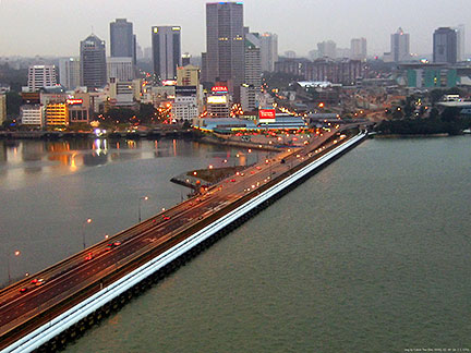 Johor Bahru with the Johor-Singapore Causeway in the foreground, the causeway connects Johor Baru to Woodlands, Singapore. Johor Bahru with the Johor-Singapore Causeway in the foreground, the causeway connects Johor Baru to Woodlands, Singapore.Image: Calvin Teo Some of the attractions of JB are, the Istana Pasir Pelangi, the royal palace of the Tunku Mahkota of Johor (Crown Prince), and the Istana Bukit Serene, the official residence of the Sultan of Johor (both not open for the public). Dataran Bandaraya is Johor Bahru's main square. Danga Bay (Teluk Danga), a large recreational park about 7 km outside the city. Legoland Malaysia (Malaysia's first international theme park). Places of worship are the Sultan Abu Bakar State Mosque, located near the Zoo Johor, Old Chinese Temple, one of the oldest buildings in the city, and the Arulmigu Sri Rajakaliamman Glass Temple, a major Hindu temple. The Map shows a city map of Johor Bahru with expressways, main roads and streets, zoom out to find the location of Senai International Airport (IATA Code: JHB) located about 25 km (15.5 mi) by road (via Route 1) north of the city in the town of Senai. To find a location use the form below. |
|
| To find a location type: street or place, city, optional: state, country. |
Local Time Johor Bahru:
Saturday-April-27 12:11
(UTC/GMT +8 hours) |
|
φ Latitude, λ Longitude (of Map center; move the map to see coordinates): , |
||||||
| Google Earth: Searchable map/satellite view of Johor Bahru, Federation of Malaysia. City Coordinates: 1°29′00″N 103°44′00″E |
Bookmark/share this page |
|||||
|
|
||||||
| More about Malaysia and Singapore: Cities: Country: Malaysia Key Statistical Data. Continent: External Links Johor Bahru Johor Bahru Municipal Government website. Wikipedia: Johor Bahru |
Singapore/Johor Bahru Weather Conditions: Weather station at Singapore Seletar airport, just south of Johor Bahru.
|
Related Consumer Information:
|
||||
Other Major Cities in South East Asia: Bandar Seri Begawan, Bandung, Bangkok, Hanoi, Ho Chi Minh City (Saigon), Jakarta, Manila, Medan, Phnom Penh, Singapore, Surabaya, Vientiane, Yangon Searchable Maps of other Countries in South East Asia: Brunei, Cambodia, Indonesia, Laos, Malaysia, Myanmar (Burma), Philippines, Singapore, Thailand, Vietnam |
||
Map Help [ show ] |
||
One World - Nations Online .:. let's care for this planet Promote that every nation assumes responsibility for our world. Nations Online Project is made to improve cross-cultural understanding and global awareness. More signal - less NOISE |
| Site Map
| Information Sources | Disclaimer | Copyright © 1998-2023 :: nationsonline.org |

