Nations Online
All Countries in the World
Nations Online All Countries in the World | |
Home  |
___ Map and Satellite View of Indonesia |
Searchable Map of Indonesia using Google Earth Data Map is showing Indonesia, the largest archipelago in the world, situated between the Indian Ocean (to the South) and the South China Sea (Pacific Ocean, in North). Map is showing Indonesia, the largest archipelago in the world, situated between the Indian Ocean (to the South) and the South China Sea (Pacific Ocean, in North). The country consists of more than 17,000 islands, the largest are Sumatra, Java, Borneo (known as "Kalimantan" in Indonesia), Sulawesi, and New Guinea, most of the larger islands are mountainous, with peaks ranging between 3,000 and 3,800 m. 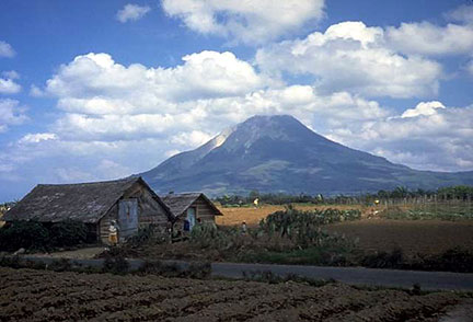 Mount Sinabung, a volcano on the island of Sumatra. The long time inactive volcano erupted in 2010. Image: Tom Casadevall Capital city of Indonesia is Jakarta on the island of Java (pop. 10 million), other major cities: Bandung, Medan, Surabaya. Official language is Indonesian. Countries with international borders to Indonesia are Malaysia, Papua New Guinea, and Timor-Leste. Indonesia shares maritime borders with: Australia, India, Palau, the Philippines, Singapore, Thailand, and Vietnam. The Map shows Indonesia with cities, expressways, main roads and streets. |
|
| To find a location type: street or place, city, optional: state, country. |
Local Time Jakarta:
Saturday-April-27 05:17
Time zone: Western Indonesian Time (WIB) :: UTC/GMT +7 hours |
|
φ Latitude, λ Longitude (of Map center; move the map to see coordinates): , |
||||||
| Sorry! Google's pricing policy has made it impossible for us to continue showing Google Maps. We apologize for any inconvenience. Google Map: Searchable map and satellite view of the Republic of Indonesia. | Bookmark/share this page |
|||||
|
|
||||||
| More about Indonesia: Cities: Country: Indonesia key statistical data. Continent: |
Current Weather Conditions Jakarta:
|
Related Consumer Information:
|
||||
Searchable Maps of other Countries in South East Asia: Brunei, Cambodia, Indonesia, Laos, Malaysia, Myanmar (Burma), Philippines, Singapore, Thailand, Vietnam |
||
Map Help [ show ] |
||
One World - Nations Online .:. let's care for this planet Promote that every nation assumes responsibility for our world. Nations Online Project is made to improve cross-cultural understanding and global awareness. More signal - less NOISE |
| Site Map
| Information Sources | Disclaimer | Copyright © 1998-2023 :: nationsonline.org |

