One Planet
Nations Online

All Countries in the World


___ Map of Central America and the Caribbean


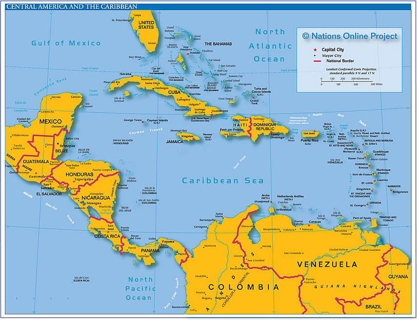
Small Reference Map of Central America and the Caribbean (West Indies).

Political Map of Central America, the Caribbean (West Indies), with Greater Antilles, and Lesser Antilles.
Click on the map to enlarge.

Map of Central America and the Caribbean
The map shows the states of Central America and the Caribbean with their national borders, their national capitals, as well as major cities, rivers, and lakes.
 
More about The Americas:

Related Categories:
Flags of the Americas
Languages of the Americas

Reference maps:
Searchable Maps of Countries and Capital Cities of the Americas
US States Maps
Political Map of the Caribbean
Political Map of North America
Physical Map of North America
Political Map of South America
Map of Central America and the Caribbean
 
Conditions Nassau, Bahamas


Related Consumer Information:

Countries and Territories in the Caribbean:
Antigua and Barbuda | Anguilla | Aruba | Bahamas | Barbados | British Virgin Islands | Cuba
Dominica | Dominican Republic | Grenada | Guadeloupe | Haiti | Jamaica | Martinique
Montserrat | Netherlands Antilles | Puerto Rico | Saint Kitts and Nevis | Saint Lucia
Saint Vincent and the Grenadines | Trinidad and Tobago | U.S. Virgin Islands

Countries of Middle and Central America:
Belize | Costa Rica | El Salvador | Guatemala | Honduras | Mexico | Nicaragua | Panama
 
Searchable Maps of Greater Antilles:
Cuba, Haiti, Dominican Republic, Jamaica, Puerto Rico

Searchable Maps of Lesser Antilles:
Anguilla, Antigua and Barbuda, Aruba (NL), Bahamas, Barbados, Bermuda, CuraƧao (NL), Dominica,
Grenada, Guadeloupe (FR), Martinique (FR), Montserrat (UK), Netherlands Antilles, Saint Kitts and Nevis,
Saint Lucia, Saint Martin (Sint Maarten), Saint Vincent and the Grenadines, Trinidad and Tobago, Virgin Islands

Maps of Caribbean Islands (Greater Antilles)
Cuba Map, Dominican Republic Map, Haiti Map, Jamaica Map, Puerto Rico Map


up