Nations Online
All Countries in the World
Nations Online All Countries in the World | |
Home  |
___ Satellite View and Map of Antigua and Barbuda |
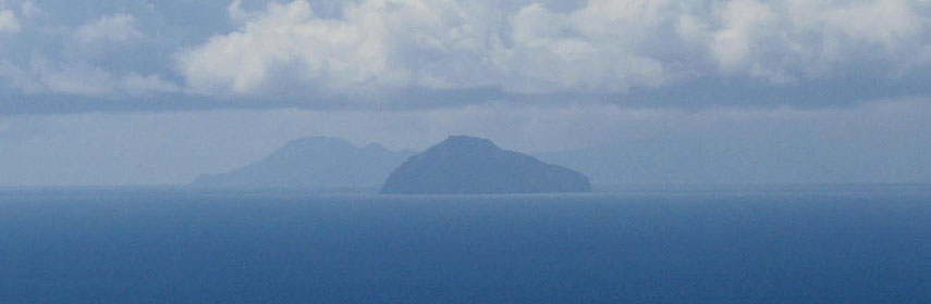 Redonda the small uninhabited island is part of Antigua and Barbuda, seen from Nevis Peak on Nevis island (in the distance the island of Montserrat) Photo: Invertzoo |
Satellite View of Antigua and Barbuda using Google Earth Data Satellite view is showing Antigua and Barbuda the tropical Caribbean islands between the Caribbean Sea and the North Atlantic Ocean, east-southeast of Puerto Rico,
Barbuda lies to the north of Antigua. Capital City is St. John's. Official language is English. Satellite view is showing Antigua and Barbuda the tropical Caribbean islands between the Caribbean Sea and the North Atlantic Ocean, east-southeast of Puerto Rico,
Barbuda lies to the north of Antigua. Capital City is St. John's. Official language is English.Neighboring islands are Montserrat, Saint Kitts and Nevis and Guadeloupe. The map shows Antigua and Barbuda with cities, towns, main roads and streets, the islands V.C. Bird International Airport (IATA code: ANU), is located 8 km (5 mi) northeast of St. John's. Zoom out to find Redonda Island west of Antigua. Zoom out to see the location of Antigua and Barbuda within the Caribbean. To find a location use the form below. To view just the map, click on the "Map" button. |
|
| To find a location type: street or place, city, optional: state, country. |
Local Time Antigua and Barbuda:
Sunday-April-28 17:32
UTC/GMT -4 hours |
|
φ Latitude, λ Longitude (of Map center; move the map to see coordinates): , |
||||||
| Google Maps: Searchable Map of Antigua and Barbuda. |
Bookmark/share this page |
|||||
| More about Antigua and Barbuda: Cities: Country: Continent: | Weather Conditions St. John's: Weather station at V.C. Bird International Airport
|
Related Consumer Information:
|
||||
Searchable Maps of Greater Antilles: Cuba, Haiti, Dominican Republic, Jamaica, Puerto Rico Searchable Maps of Lesser Antilles: Anguilla (UK), Antigua and Barbuda, Aruba (NL), Bahamas, Barbados, Bermuda, Curaçao (NL), Dominica, Grenada, Guadeloupe (FR) Martinique (FR), Montserrat (UK), Netherlands Antilles, Saint Kitts and Nevis, Saint Lucia, Saint Martin (Sint Maarten), Saint Vincent and the Grenadines, Trinidad and Tobago, Virgin Islands Maps of Caribbean Islands (Greater Antilles) Cuba Map, Dominican Republic Map, Haiti Map, Jamaica Map, Puerto Rico Map Countries and Territories of the Americas |
||||||
Map Help [ show ] |
||||||
One World - Nations Online .:. let's care for this planet Promote that every nation assumes responsibility for our world. Nations Online Project is made to improve cross-cultural understanding and global awareness. More signal - less NOISE |
| Site Map
| Information Sources | Disclaimer | Copyright © 1998-2023 :: nationsonline.org |

