Nations Online
All Countries in the World
Nations Online All Countries in the World | |
Home  |
___ Satellite View and Map of Saint Vincent and the Grenadines |
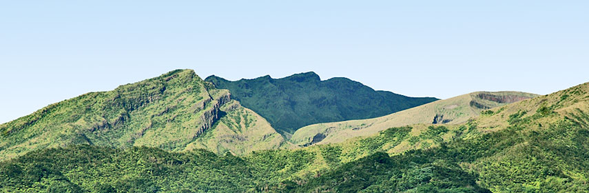 Soufriere volcano on St. Vincent. Image: Soufriere |
About Saint Vincent and the Grenadines Satellite view is showing Saint Vincent and the Grenadines, a chain of small islands situated in the Caribbean Sea and the North Atlantic Ocean, between Saint Lucia and Grenada, west of Barbados. Satellite view is showing Saint Vincent and the Grenadines, a chain of small islands situated in the Caribbean Sea and the North Atlantic Ocean, between Saint Lucia and Grenada, west of Barbados.The island nation consists of its largest island Saint Vincent and several smaller islands, airports are on Bequia Island, Canouan Island, Carriacou Island, Mustique Island, and Union Island. And yes, Columbus was here as well. After Columbus discovered the island in 1498, European efforts at colonization were met with fierce resistance from the local Carib Indians. The island was not settled until 1762 by the British, only to be captured by the French in 1779, it was returned to Great Britain in 1783. SVG is independent since 1979, within the British Commonwealth. Saint Vincent is of volcanic origin, its highest point is La Soufriere, an active stratovolcano with a crater lake and a height of 1,234 m. The last recorded eruption was in April 1979. SVG occupies an area of 389 km² (Saint Vincent 344 km²). The island nation is densely populated with 110,000 people (in 2012). Capital, chief port, and main commercial center of SVG is Kingstown (pop 25,000). Spoken languages are English (official) and English Creole. The map shows Saint Vincent and the Grenadines with cities, towns, expressways, main roads and streets, and the location of E. T. Joshua Airport (IATA code: SVD) and the four other airports on the islands. Zoom out to see the location of Saint Vincent and the Grenadines within the Caribbean. To find a location use the form below. |
|
| To find a location type: street or place, city, optional: state, country. |
Local Time Saint Vincent and the Grenadines:
Sunday-April-28 17:05
Standard time zone: Atlantic Standard Time (AST); UTC/GMT -4 hours. |
|
φ Latitude, λ Longitude (of Map center; move the map to see coordinates): , |
||||||
| Google Maps: Searchable Map of Saint Vincent and the Grenadines. |
Bookmark/share this page |
|||||
| More about Saint Vincent and the Grenadines: Cities: Country: Continent: |
Weather Conditions Kingstown:
|
Related Consumer Information:
|
||||
Searchable Maps of Greater Antilles: Cuba, Haiti, Dominican Republic, Jamaica, Puerto Rico Searchable Maps of Lesser Antilles: Anguilla (UK), Antigua and Barbuda, Aruba (NL), Bahamas, Barbados, Bermuda, Curaçao (NL), Dominica, Grenada Guadeloupe (FR), Martinique (FR), Montserrat (UK), Netherlands Antilles, Saint Kitts and Nevis, Saint Lucia Saint Martin (Sint Maarten), Trinidad and Tobago, Virgin Islands Maps of Caribbean Islands (Greater Antilles) Cuba Map, Dominican Republic Map, Haiti Map, Jamaica Map, Puerto Rico Map Countries and Territories of the Americas |
||||||
Map Help [ show ] |
||||||
One World - Nations Online .:. let's care for this planet Promote that every nation assumes responsibility for our world. Nations Online Project is made to improve cross-cultural understanding and global awareness. More signal - less NOISE |
| Site Map
| Information Sources | Disclaimer | Copyright © 1998-2023 :: nationsonline.org |

