Nations Online
All Countries in the World
Nations Online All Countries in the World | |
Home  |
___ Satellite View and Map of The Bahamas |
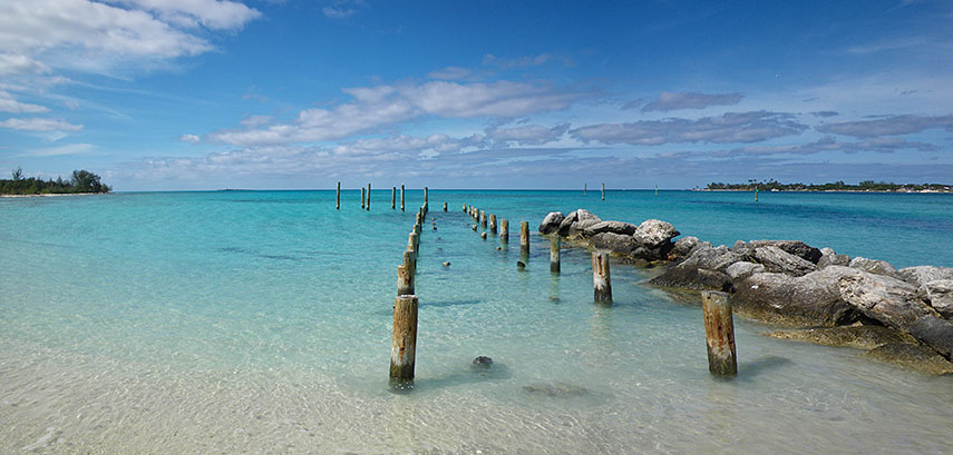 Jaws Beach on New Providence Island in the Bahamas. - Image: Bryce Edwards |
About The Bahamas Satellite view/map is showing the islands of The Bahamas, an archipelago consisting of 29 islands, 661 cays, and 2,387 rocks. Satellite view/map is showing the islands of The Bahamas, an archipelago consisting of 29 islands, 661 cays, and 2,387 rocks. The Bahamas are located in the northwestern West Indies in the Atlantic Ocean, south-east of Florida (USA) and to the north of Cuba, the island of Hispaniola (Dominican Republic and Haiti) and the Caribbean Sea. Main islands are Abaco, Acklins, Andros Island (largest island), Bimini (closest island to the United States), Cat Island, Crooked Island, Eleuthera, Exuma, Grand Bahama, Inagua, Long Island, Mayaguana, and San Salvador Island. The islands are the surface of the Bahama Banks, submerged limestone platforms, deposits of marine organisms built up in a time scale of millions of years. It was here that Columbus first landed in the New World (Oct. 12, 1492). The islands were a British colony from the 18th century until they gained independence within the Commonwealth of Nations in 1973. Nassau is the largest city and capital of the Bahamas located on the island of New Providence. The Bahamas have a population of 370,000 people (in 2015). Spoken languages are English (official), and Creole. The map shows the archipelago of The Bahamas with cities, main roads and streets, and the location of Bahamas’ Airports: Lynden Pindling International Airport, is Bahamas' main airport (IATA code: NAS). Andros Town Airport, also known as Fresh Creek Airport (IATA Code: ASD). Grand Bahama International Airport (IATA Code: FPO) is an airport located in Freeport. North Eleuthera Airport (IATA Code: ELH) is located on Eleuthera island. San Salvador Airport (IATA Code: ZSA) is located on the island of San Salvador. To find a location use the form below. |
|
| To find a location type: street or place, city, optional: state, country. |
Local Time Bahamas:
Sunday-April-28 2024 22:30
Standard time zone Eastern (EST): UTC/GMT -5 hoursDaylight Saving Time (EDT) in use from the second Sunday in March, ends on the first Sunday in November; time zone offset: UTC/GMT -4 hours |
|
φ Latitude, λ Longitude (of Map center; move the map to see coordinates): , |
||||||
| Map and Satellite View of the Commonwealth of the Bahamas. |
Bookmark/share this page |
|||||
| More about the Bahamas: Map is showing the capital of the Bahamas. Political Map of The Bahamas Outline of Bahma's history. Reference Map of Central America and the Caribbean. |
Current Weather Conditions Nassau
|
Related Consumer Information:
|
||||
Searchable Maps of Greater Antilles: Cuba, Haiti, Dominican Republic, Jamaica, Puerto Rico Searchable Maps of Lesser Antilles: Anguilla (UK), Antigua and Barbuda, Aruba (NL), Bahamas, Barbados, Bermuda, Curaçao (NL), Dominica, Grenada, Guadeloupe (FR) Martinique (FR), Montserrat (UK), Netherlands Antilles, Saint Kitts and Nevis, Saint Lucia, Saint Martin (Sint Maarten), Saint Vincent and the Grenadines, Trinidad and Tobago, Virgin Islands Maps of Caribbean Islands (Greater Antilles) Cuba Map, Dominican Republic Map, Haiti Map, Jamaica Map, Puerto Rico Map Countries and Territories of the Americas |
||||||
Map Help [ show ] |
||||||
One World - Nations Online .:. let's care for this planet Promote that every nation assumes responsibility for our world. Nations Online Project is made to improve cross-cultural understanding and global awareness. More signal - less NOISE |
| Site Map
| Information Sources | Disclaimer | Copyright © 1998-2023 :: nationsonline.org |

