Nations Online
All Countries in the World
Nations Online All Countries in the World | |
Home  |
___ Satellite View and Map of Dominica |
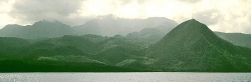 Morne Diablotins, largest and highest volcano on Dominica. Image: Lee Siebert, Smithsonian Institution |
Searchable Map and Satellite View of Dominica using Google Earth Data Satellite view is showing the island of Satellite view is showing the island of With an area of 751 km² (289.5 sq mi) the island is slightly larger than Singapore, or slightly more than four times the size of Washington, DC. The island has a coastline of 148 km, its landscape is mountainous of volcanic origin, highest Peak is Morne Diablotin with 1,447 m (4,747 ft). The most northern of the Windward Islands has a population of of 72,000 inhabitants (in 2014). Capital and largest city is Roseau. Spoken languages are English (official) and a French based Antillean Creole (Kwéyòl). Other Windward islands are: Grenada, Saint Lucia, and Saint Vincent and the Grenadines. The map shows Dominica with cities, towns, expressways, main roads and streets. Dominica's main airport Douglas-Charles Airport (Melville Hall; IATA code: DOM) is located north east of the capital Roseau, 46 km by road via Dr Nicholas Liverpool Highway/Wiers Road, the smaller Cane Field Airport (IATA code: DCF) lies 5 km north of the capital (via Edward Oliver Leblanc Highway). Zoom out to see the location of Dominica within the Caribbean Sea. To find a location use the form below. |
|
| To find a location type: street or place, city, optional: state, country. |
Local Time Dominica:
Monday-April-29 01:04
Atlantic Standard Time (AST) :: UTC/GMT -4 hours |
|
φ Latitude, λ Longitude (of Map center; move the map to see coordinates): , |
||||||
| Google Maps: Searchable Map of Dominica. |
Bookmark/share this page |
|||||
| More about Dominica: |
Weather Conditions Dominica:
|
Related Consumer Information:
|
||||
Searchable Maps of Greater Antilles: Cuba, Haiti, Dominican Republic, Jamaica, Puerto Rico Searchable Maps of Lesser Antilles: Anguilla (UK), Antigua and Barbuda, Aruba (NL), Bahamas, Barbados, Bermuda, Curaçao (NL), Dominica, Grenada, Guadeloupe (FR), Martinique (FR), Montserrat (UK), Netherlands Antilles, Saint Kitts and Nevis, Saint Lucia, Saint Martin (Sint Maarten), Saint Vincent and the Grenadines, Trinidad and Tobago, Virgin Islands Maps of Caribbean Islands Cuba Map, Dominica Map, Dominican Republic Map, Haiti Map, Jamaica Map, Puerto Rico Map Countries and Territories of the Americas |
||||||
Map Help [ show ] |
||||||
One World - Nations Online .:. let's care for this planet Promote that every nation assumes responsibility for our world. Nations Online Project is made to improve cross-cultural understanding and global awareness. More signal - less NOISE |
| Site Map
| Information Sources | Disclaimer | Copyright © 1998-2023 :: nationsonline.org |

