Nations Online
All Countries in the World
Nations Online All Countries in the World | |
Home  |
___ Satellite View and Map of Grenada (Camerhogne) |
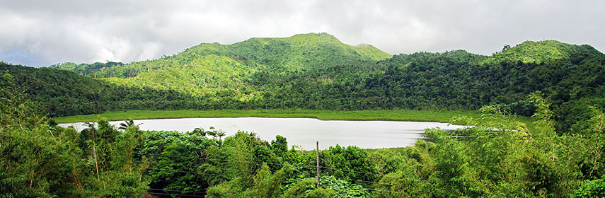 Crater lake within Grand Etang Nature Reserve - Image: Bgabel |
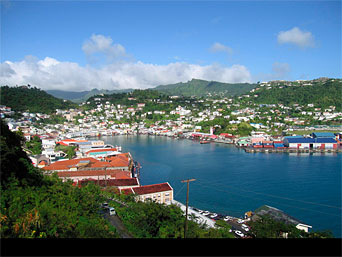
About Grenada Map is showing the island nation of Grenada which consists of the main island of Grenada, known as the "Spice Island", and and 8 smaller satellite islands, Carriacou, Petit Martinique, Ronde Island, Caille Island, Diamond Island, Large Island, Saline Island, and Frigate Island. Map is showing the island nation of Grenada which consists of the main island of Grenada, known as the "Spice Island", and and 8 smaller satellite islands, Carriacou, Petit Martinique, Ronde Island, Caille Island, Diamond Island, Large Island, Saline Island, and Frigate Island. The archipelago is situated between the Caribbean Sea and Atlantic Ocean, north of Trinidad and Tobago, south of Saint Vincent and the Grenadines and northeast of Venezuela. Grenada belongs to the Windward Islands, it has a population of 107,000 inhabitants (in 2015). Grenada's capital and largest city is St. George's. Spoken languages are English (official) and Grenadian Creole English and Grenadian Creole French. The map shows Grenada with cities, towns, expressways, main roads and streets, and the location of Maurice Bishop International Airport (IATA code: GND). Zoom out to see the location of Grenada within the Caribbean. To find a location use the form below. |
|
| To find a location type: street or place, city, optional: state, country. |
Local Time Grenada:
Thursday-July-9 02:41
UTC/GMT -4 hours |
|
φ Latitude, λ Longitude (of Map center; move the map to see coordinates): , |
||||||
| Google Maps: Searchable Map of Grenada. Coordinates: 12°3′N 61°45′W |
Bookmark/share this page |
|||||
| More about Grenada: Cities: Country: Continent: External Link Wikipedia: Saint George's | Current Weather Conditions Saint George's: Weather station at Point Salines Airport
|
Related Consumer Information:
| ||||
Searchable Maps of Greater Antilles: Cuba, Haiti, Dominican Republic, Jamaica, Puerto Rico Searchable Maps of Lesser Antilles: Anguilla (UK), Antigua and Barbuda, Aruba (NL), Bahamas, Barbados, Bermuda, Curaçao (NL), Dominica, Guadeloupe (FR) Martinique (FR), Montserrat (UK), Netherlands Antilles, Saint Kitts and Nevis, Saint Lucia, Saint Martin (Sint Maarten), Saint Vincent and the Grenadines, Trinidad and Tobago, Virgin Islands Maps of Caribbean Islands (Greater Antilles) Cuba Map, Dominican Republic Map, Haiti Map, Jamaica Map, Puerto Rico Map Countries and Territories of the Americas |
||||||
Map Help [ show ] |
||||||
One World - Nations Online .:. let's care for this planet Promote that every nation assumes responsibility for our world. Nations Online Project is made to improve cross-cultural understanding and global awareness. More signal - less NOISE |
| Site Map
| Information Sources | Disclaimer | Copyright © 1998-2024:: nationsonline.org |