Nations Online
All Countries in the World
Nations Online All Countries in the World | |
Home  |
___ Satellite View and Map of Jamaica |
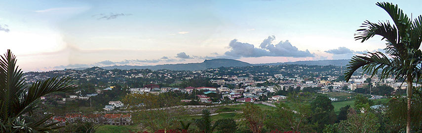 View from Bloomfield Great Hall looking north over Mandeville. Image: Op. Deo |
About Jamaica Satellite view is showing the island nation in the Caribbean Sea, situated 900 km south of Miami. Jamaica shares maritime borders with Cayman Islands (United Kingdom), Colombia, Cuba, and Haiti. Related Caribbean island nations are: Dominican Republic and Haiti on the island of Hispaniola, and Puerto Rico. The Jamaica's landscape is mountainous, with narrow coastal plains. The highest point is Blue Mountain Peak (2,256 m) in the Blue Mountains National Park in the east of the island. Satellite view is showing the island nation in the Caribbean Sea, situated 900 km south of Miami. Jamaica shares maritime borders with Cayman Islands (United Kingdom), Colombia, Cuba, and Haiti. Related Caribbean island nations are: Dominican Republic and Haiti on the island of Hispaniola, and Puerto Rico. The Jamaica's landscape is mountainous, with narrow coastal plains. The highest point is Blue Mountain Peak (2,256 m) in the Blue Mountains National Park in the east of the island.Jamaica occupies an area of 10,991 km², making the island slightly larger than Cyprus, or slightly smaller than the U.S. state of Connecticut. The island has a population of 2.75 million people (2015). Capital and largest city is Kingston. Official language is English but spoken is Jamaican Patois. The Map shows Jamaica with cities, expressways, main roads and streets, and the The map shows the location of Montego Bay International Airport and Kingston's Norman Manley International Airport. Zoom out to see the location of Jamaica within the Caribbean Sea. To find a location use the form below. |
||
| To find a location type: street or place, city, optional: state, country. |
Local Time Jamaica:
Sunday-June-21 15:31
UTC/GMT -5 hours |
|
|
φ Latitude, λ Longitude (of Map center; move the map to see coordinates): , |
||||||
| Sorry! Google's pricing policy has made it impossible for us to continue showing Google Maps. We apologize for any inconvenience. Google Map: Searchable map/satellite view of the island of Jamaica. |
Bookmark/share this page |
|||||
| More about Jamaica: Cities: Country: Jamaica key statistical data. Continent: |
Current Weather Conditions Kingston:
|
Related Consumer Information:
|
||||
Searchable Maps of Greater Antilles: Cuba, Haiti, Dominican Republic, Jamaica, Puerto Rico Searchable Maps of Lesser Antilles: Anguilla (UK), Antigua and Barbuda, Aruba (NL), Bahamas, Barbados, Bermuda, Curaçao (NL), Dominica, Grenada, Guadeloupe (FR) Martinique (FR), Montserrat (UK), Netherlands Antilles, Saint Kitts and Nevis, Saint Lucia, Saint Martin (Sint Maarten), Saint Vincent and the Grenadines, Trinidad and Tobago, Virgin Islands Maps of Caribbean Islands (Greater Antilles) Cuba Map, Dominican Republic Map, Haiti Map, Jamaica Map, Puerto Rico Map Countries and Territories of the Americas |
||||||
Map Help [ show ] |
||||||
One World - Nations Online .:. let's care for this planet Promote that every nation assumes responsibility for our world. Nations Online Project is made to improve cross-cultural understanding and global awareness. More signal - less NOISE |
| Site Map
| Information Sources | Disclaimer | Copyright © 1998-2024:: nationsonline.org |

