Nations Online
All Countries in the World
Nations Online All Countries in the World | |
Home  |
___ Satellite View and Map of Cuba |
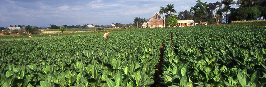 A Tobaco field, source of the famous Cuban cigars. Image: Kotoviski |
About Cuba Satellite view is showing Cuba in the western West Indies, the largest Caribbean island is located south of Florida and The Bahamas, east of Mexico's Yucatan peninsula, and north of the Caribbean Sea with Jamaica and the Cayman Islands. Cuba shares maritime borders with The Bahamas, Haiti, Honduras, Jamaica, Mexico, and the United States. Satellite view is showing Cuba in the western West Indies, the largest Caribbean island is located south of Florida and The Bahamas, east of Mexico's Yucatan peninsula, and north of the Caribbean Sea with Jamaica and the Cayman Islands. Cuba shares maritime borders with The Bahamas, Haiti, Honduras, Jamaica, Mexico, and the United States.Cuba occupies an area of 110,000 km², compared it is about the size of Bulgaria, or slightly smaller than the U.S. state of Pennsylvania. Cuba's landscape is mostly flat with gently rolling plains, there are rugged hills and mountains at the southern end of the island. The island nation has a population of 11.23 million (official estimate 2014). Capital city is Habana (Havana). Official language is Spanish. The Map shows a map of Cuba with cities, expressways, and main roads. Zoom out to see the location of Cuba within the Caribbean. To find a location use the form below. To view just the map, click on the "Map" button. |
|
| To find a location type: street or place, city, optional: state, country. |
Local Time Havana:
Saturday-April-27 07:00
Time zone: Cuba Standard Time (CST ) = UTC/GMT -5 hours
Daylight saving time (DST) from mid March till end of October UTC/GMT -4 hours |
|
φ Latitude, λ Longitude (of Map center; move the map to see coordinates): , |
||||||
| Sorry! Google's pricing policy has made it impossible for us to continue showing Google Maps. We apologize for any inconvenience. Google Map: Searchable map and satellite view of the Republic of Cuba (Republica de Cuba). |
Bookmark/share this page |
|||||
| More about Cuba: Cities: Country: Cuba key statistical data. Continent: |
Current Weather Conditions Havana
|
Related Consumer Information:
|
||||
Searchable Maps of Greater Antilles: Haiti, Dominican Republic, Jamaica, Puerto Rico Searchable Maps of Lesser Antilles: Anguilla (UK), Antigua and Barbuda, Aruba (NL), Bahamas, Barbados, Bermuda, Curaçao (NL), Dominica, Grenada, Guadeloupe (FR) Martinique (FR), Montserrat (UK), Netherlands Antilles, Saint Kitts and Nevis, Saint Lucia, Saint Martin (Sint Maarten), Saint Vincent and the Grenadines, Trinidad and Tobago, Virgin Islands Maps of Caribbean Islands (Greater Antilles) Dominican Republic Map, Haiti Map, Jamaica Map, Puerto Rico Map Countries and Territories of the Americas |
||||||
Map Help [ show ] |
||||||
One World - Nations Online .:. let's care for this planet Promote that every nation assumes responsibility for our world. Nations Online Project is made to improve cross-cultural understanding and global awareness. More signal - less NOISE |
| Site Map
| Information Sources | Disclaimer | Copyright © 1998-2023 :: nationsonline.org |

