Nations Online
All Countries in the World
Nations Online All Countries in the World | |
Home  |
___ Satellite View and Map of the City of Tokyo (東京) |
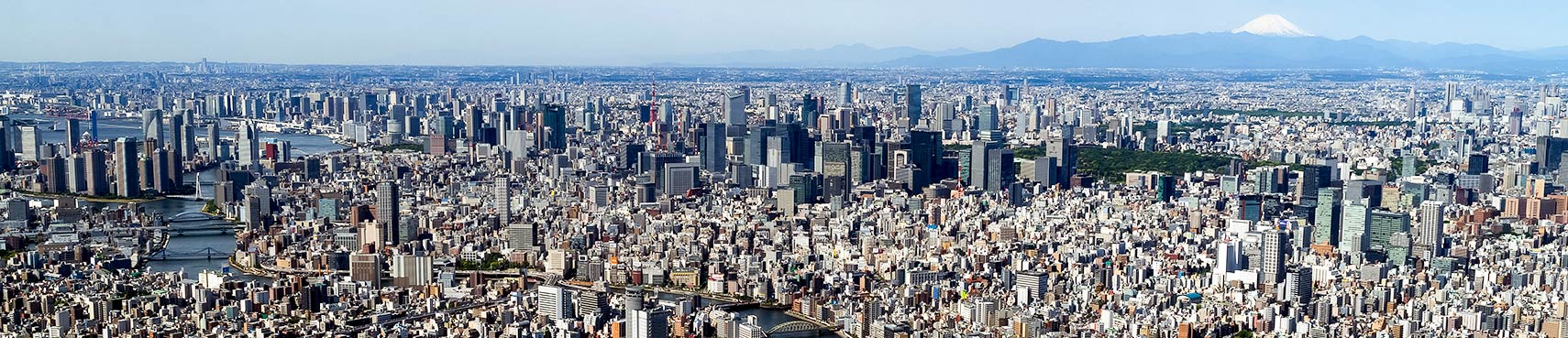 Panorama of Tokyo seen from top of SkyTree, the tallest TV tower in the world with a height of 634 m. Mt Fuji in the background. Image: Yodalica |
About Tokyo Satellite view is showing Tokyo, the national capital of Satellite view is showing Tokyo, the national capital of Tokyo consists of the southwestern part of the Kanto Region, the Izu Islands, and the Ogasawara islands. The mega city has a population of 9.3 million inhabitants in its metropolitan area with its 23 special wards (ku) of Tokyo-to (東京都).  Shibuya Toyoko-Line, the Tokyu Toyoko Line is a major railway line connecting Tokyo to Yokohama, transporting hundreds of people in long trains every two or three minutes to and from Shibuya station, one of the busiest commuter rail station in Japan with more than 2 million passengers daily. Photo: Joi Ito Tokyo is today the industrial, commercial, educational and cultural center of Japan with numerous universities, colleges, research institutes, theaters and museums. Just zoom in (+) to see Kōkyo, the Tokyo Imperial Palace, the residence of the Emperor of Japan, it is the big green park in the middle of Tokyo's most expensive real estate area. East of the Palace is Tokyo Station, terminal of multiple shinkansen lines. South east of the station there begins the Ginza, Tokyo's most famous upmarket shopping, dining and entertainment district. The Map shows a city map of Tokyo with expressways, main roads and streets, Tokyo International Haneda Airport (IATA code: HND) is located 14 km (8.7 mi) south of Tokyo Station; zoom out (-) to find Narita International Airport (IATA code: NRT) located in Narita, Chiba, in Marunouchi business district. The distance by road from Tokyo Station is 67.5 km (42 mi). To find a location use the form below. |
|
| To find a location type: street or place, city, optional: state, country. |
Local Time Tokyo
Friday-June-26 17:55
UTC/GMT +9 hours |
|
φ Latitude, λ Longitude (of Map center; move the map to see coordinates): , |
||||||
| Google Earth: Searchable map/satellite view of Tokyo, Japan. City Coordinates: 35°42′2″N 139°42′54″E |
Bookmark/share this page |
|||||
| More about Japan: Landmarks: Mount Fuji Cities: Searchable map/satellite view of Japan's largest cities: Country: Continent: World: |
Weather Conditions Tokyo
External Links: Tokyo (official website) Tokyo (official tourism website) Haneda Airport (Tokyo International Airport) Narita International Airport (Tokyo's second International Airport) Tokyo City View Panorama of the sprawling metropolis of Tokyo, Shibuya, Yokohama, from the observation deck of Mori Tower. Wikipedia: Tokyo |
Explore More:
Related Consumer Information:
|
||||
| Major Cities in Eastern Asia Bangkok, Beijing, Busan, Chongqing, Colombo, Delhi, Fukuoka, Guangzhou, Hanoi, Ho Chi Minh City, Hong Kong, Islamabad, Jakarta, Karachi, Kobe, Kolkata, Kuala Lumpur, Kyoto, Lahore, Lhasa, Macao, Manila, Mumbai, Nagoya, Osaka, Phnom Penh, Pyongyang, Sapporo, Seoul, Shanghai, Shenzhen, Singapore, Taipei, Tianjin, Tokyo, Ulaanbaatar, Yangon, Yokohama |
||||||
Map Help [ show ] |
||||||
One World - Nations Online .:. let's care for this planet Promote that every nation assumes responsibility for our world. Nations Online Project is made to improve cross-cultural understanding and global awareness. More signal - less NOISE |
| Site Map
| Information Sources | Disclaimer | Copyright © 1998-2024:: nationsonline.org |

