Nations Online
All Countries in the World
Nations Online All Countries in the World | |
Home  |
___ Satellite View and Map of the City of Osaka (大阪市), Japan |
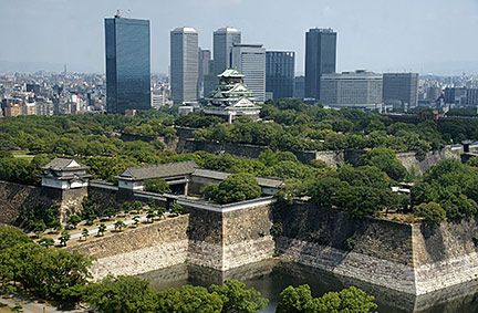
About Osaka Satellite view showing Osaka, Japan's second city and the third most populous municipality in the country (behind Yokohama). It is also known as the gourmet food capital of Japan. Satellite view showing Osaka, Japan's second city and the third most populous municipality in the country (behind Yokohama). It is also known as the gourmet food capital of Japan. The capital city of Osaka Prefecture is located at the estuary mouth of the Yodo River on Osaka Bay at the south coast of Honshu, Japan's main island. The city is one of the primary centers of Japan's economy and traditionally the commercial capital of Japan, and in contrast, it is also the center of the Japanese next-generation robot industry. Osaka has a population of about 2.6 million inhabitants (at night, in daytime it rises to more than 3.5 million). The city is part of the Keihanshin metropolitan area along with Kobe and Kyoto. More than 18 million people live in Keihanshin, which is Japan's second most populated urban region. The map shows a city map of Osaka with expressways, main roads and streets, and the location of Osaka Itami International Airport (IATA code: ITM). Zoom out to find the location of Kansai International Airport (IATA code: KIX), located on an artificial island southwest of Osaka. To find a location use the form below. |
|
| To find a location type: street or place, city, optional: state, country. |
Local Time Osaka:
Sunday-April-28 09:14
UTC/GMT +9 hours |
|
φ Latitude, λ Longitude (of Map center; move the map to see coordinates): , |
||||||
| Google Earth: Searchable Map and Satellite view of Osaka, Kansai region, Japan. City Coordinates: 34°42′N 135°30′E |
Bookmark/share this page |
|||||
| More about Japan: Landmarks: Mount Fuji Cities: Searchable map/satellite view of Japan's largest cities: Country: Continent: External Links: Osaka (official city web site) Osaka Itami International Airport Kansai International Airport Wikipedia: Osaka |
Current Weather Conditions Osaka
|
Related Consumer Information:
|
||||
| Major Cities in Eastern Asia Bangkok, Beijing, Busan, Chongqing, Colombo, Delhi, Fukuoka, Guangzhou, Hanoi, Ho Chi Minh City, Hong Kong, Islamabad, Jakarta, Karachi, Kobe, Kolkata, Kuala Lumpur, Kyoto, Lahore, Lhasa, Macao, Manila, Mumbai, Nagoya, Osaka, Phnom Penh, Pyongyang, Sapporo, Seoul, Shanghai, Shenzhen, Singapore, Taipei, Tianjin, Tokyo, Ulaanbaatar, Yangon, Yokohama |
||||||
Map Help [ show ] |
||||||
One World - Nations Online .:. let's care for this planet Promote that every nation assumes responsibility for our world. Nations Online Project is made to improve cross-cultural understanding and global awareness. More signal - less NOISE |
| Site Map
| Information Sources | Disclaimer | Copyright © 1998-2023 :: nationsonline.org |