Nations Online
All Countries in the World
Nations Online All Countries in the World | |
Home  |
___ Famous Landmarks: Sacred Mountains - Satellite View of Mount Fuji (富士山, Fuji-san), Japan |
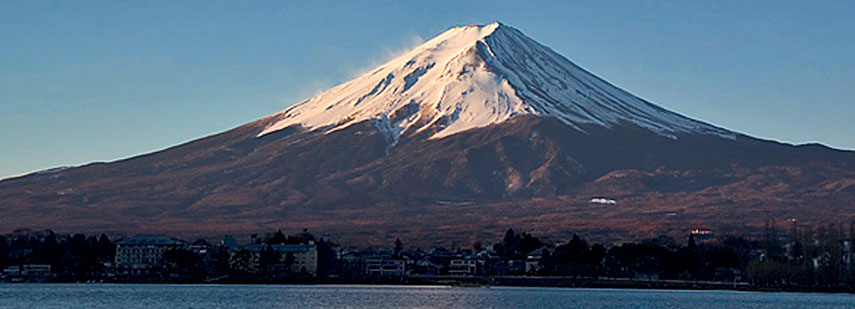 Mount Fuji at sunrise from across Lake Kawaguchi, Yamanashi Prefecture, Japan. Image: Frank Gualtieri (Fg2) |
About Mount FujiMount Fuji or sometimes also Fujiyama is associated by people around the world with Japan. The dormant stratovolcano with its well-known cone-shaped silhouette has an elevation of 3,776 m (12.388 ft) and is the highest peak in Japan. Mt. Fuji is located on the Southern Honshu Island in the Fuji-Hakone-Izu National Park, about 100 km (60 miles) south west of Tokyo, it is one of Japan's "Three Holy Mountains".The dormant volcano is actually an active volcano, even though its last last eruption was at the end of 1707. But Mount Fuji is closely watched, especially after the Tohoku earthquake in 2011, a recent rise of the internal pressure in its magma chamber has put the mountain in an imminent eruptive state, some experts expect it might happen in 2015. Like many other mountains in the world Mt. Fuji is connected with legends and devotional beliefs. According to legends and folk tales demons, ghosts, and other magical beings are haunting in the dense Aokigahara forest, the Sea of Trees, also known as the Suicide Forest, at the northwest base of the mountain. Many temples and shrines are located on and around the volcano, the Fuji Sengen Jinja Shrine at the city of Fujinomiya is one of the basic starting points for the Mt. Fuji pilgrimage. The Fujisan Hongu Sengentaisha is the main shrine for the worship of Mount Fuji since the 9th century, the shrine is dedicated to Konohanasakuya-hime (木花咲耶姫), the blossom-princess, the Shinto Goddess of Mount Fuji. In Buddhist Fuji devotion, especially in that of the Fujikō belief is that the mountain would become the realm of the future Buddha Miroku (Maitreya). |
|
φ Latitude, λ Longitude (of Map center; move the map to see coordinates): , |
||||||
| Sorry! Google's pricing policy has made it impossible for us to continue showing Google Maps. We apologize for any inconvenience. Google Map: Satellite View of Mount Fuji, Japan. (Make sure the Terrain layer in Google Earth is checked.) |
Bookmark/share this page |
|||||
| previous landmark: Schoenbrunn Palace, Vienna |
next landmark: Mount Everest | |||||
| More about Japan: Cities: Searchable map/satellite view of Japan's largest cities: Country: Continent: External Links: Fujiyoshida City Fujisan Hongu Sengentaisha Official website of the Sengen shrine. Wikipedia: Mount Fuji Wikipedia article about Fuji-san |
Current Weather Conditions Tokyo
|
Explore More:
Related Consumer Information:
|
||||
| Major Cities in Eastern Asia Bangkok, Beijing, Busan, Chongqing, Colombo, Delhi, Fukuoka, Guangzhou, Hanoi, Ho Chi Minh City, Hong Kong, Islamabad, Jakarta, Karachi, Kobe, Kolkata, Kuala Lumpur, Kyoto, Lahore, Lhasa, Macao, Manila, Mumbai, Nagoya, Osaka, Phnom Penh, Pyongyang, Sapporo, Seoul, Shanghai, Shenzhen, Singapore, Taipei, Tianjin, Tokyo, Ulaanbaatar, Yangon, Yokohama |
||||||
Map Help [ show ] |
||||||
One World - Nations Online .:. let's care for this planet Promote that every nation assumes responsibility for our world. Nations Online Project is made to improve cross-cultural understanding and global awareness. More signal - less NOISE |
| Site Map
| Information Sources | Disclaimer | Copyright © 1998-2023 :: nationsonline.org |

