Nations Online
All Countries in the World
Nations Online All Countries in the World | |
Home  |
___ Map and Satellite View of Japan (日本 - Nippon/Nihon) |
About Japan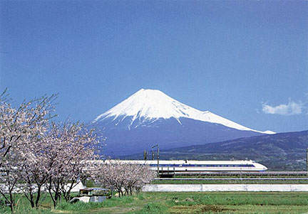 Cherry blossom at Mount Fuji, Japans highest mountain and iconic landmark with a Shinkansen bullet train passing by.  Satellite view is showing Japan, a country in eastern Asia that occupies a chain of islands in the Pacific Ocean roughly parallel with the eastern coast of the Asiatic mainland. Satellite view is showing Japan, a country in eastern Asia that occupies a chain of islands in the Pacific Ocean roughly parallel with the eastern coast of the Asiatic mainland.With an area of 377,915 km², scattered over 6000 islands, Japan is somewhat larger than Germany or slightly smaller than the US state of California. The country has a slowly shrinking population of 126.9 million inhabitants. The national capital is Tokyo. Major cities are Fukuoka, Fukushima, Kobe, Kyoto, Nagoya, Osaka, Sapporo, Sendai, and Yokohama.Official languages is Japanese The map shows Japan with administrative boundaries of Japanese Prefectures, cities, towns, expressways, main roads and streets. To find a location use the form below. |
|
| To find a location type: street or place, city, optional: state, country. |
Local Time Japan:
Monday-April-29 18:00
Time zone: Japan Standard Time (JST) :: UTC/GMT +9 hours |
|
φ Latitude, λ Longitude (of Map center; move the map to see coordinates): , |
||||||||||
| Google Maps: Searchable Map of Japan. | Bookmark/share this page |
|||||||||
| More about Japan: Landmarks: Mount Fuji Cities: Searchable map/satellite view of Japan's largest cities: Country: Continent: |
Current Weather Conditions Tokyo
Current Weather Conditions Sapporo
|
Explore More:
Related Consumer Information:
|
||||||||
Map Help [ show ] |
||||||||||
One World - Nations Online .:. let's care for this planet Promote that every nation assumes responsibility for our world. Nations Online Project is made to improve cross-cultural understanding and global awareness. More signal - less NOISE |
| Site Map
| Information Sources | Disclaimer | Copyright © 1998-2023 :: nationsonline.org |


