Nations Online
All Countries in the World
Nations Online All Countries in the World | |
Home  |
___ Satellite View and Map of the City of Ulaanbaatar (Ulan Bator - Улаанбаатар), Mongolia |
About Ulaanbaatar Satellite view is showing Ulan Bator also known as Ulaanbaatar, largest city and the national capital of Satellite view is showing Ulan Bator also known as Ulaanbaatar, largest city and the national capital of The city lies at an altitude of 1300 m, located in a valley on the banks of the sacred Tuul River (Tuul Gol) north of Bogd Khan Uul mountain, about 230 km south of Mongolia's border to Russia. 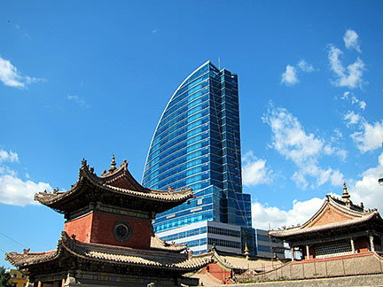 Choijin Lama Temple and the Blue Sky Hotel & Tower, old and new architecture in the city's Sukhbaatar District, the heart of Ulaanbaatar. Image: tourism.ub.gov.mn Today Ulaanbaatar is Mongolia's primate city, the cultural, economical, and industrial center of the nation. About 1.4 million people live in the city, more than one-third of Mongolia's population. Spoken language is Mongolian. The city is home to the National University of Mongolia Just zoom in (+) to see Chinggis Khaan Square, with the Government Palace. The map shows a city map of Ulaanbaatar with expressways and main roads, zoom out to find the location of Chinggis Khaan International Airport To find a location use the form below. |
|
| To find a location type: street or place, city, optional: state, country. |
Local Time Ulaanbaatar:
Saturday-April-27 10:04
UTC/GMT +8 hours |
|
φ Latitude, λ Longitude (of Map center; move the map to see coordinates): , |
||||||
| Google Maps: Searchable map/satellite view of Ulaanbaatar (Ulan Bator), Mongolia. City Coordinates: 47°55′N 106°55′E |
Bookmark/share this page |
|||||
| More about Mongolia: Mongolia key statistical data. External Links: Ulaanbaatar (official website) The UB Post Local news. Wikipedia: Ulaanbaatar |
Weather Conditions Ulaanbaatar
|
Related Consumer Information:
|
||||
| Major Cities in Eastern Asia Bangkok, Beijing, Busan, Chongqing, Colombo, Delhi, Fukuoka, Guangzhou, Hanoi, Ho Chi Minh City, Hong Kong, Islamabad, Jakarta, Karachi, Kobe, Kolkata, Kuala Lumpur, Kyoto, Lahore, Lhasa, Macao, Manila, Mumbai, Nagoya, Osaka, Phnom Penh, Pyongyang, Sapporo, Seoul, Shanghai, Shenzhen, Singapore, Taipei, Tianjin, Tokyo, Ulaanbaatar, Yangon, Yokohama |
||||||
Map Help [ show ] |
||||||
One World - Nations Online .:. let's care for this planet Promote that every nation assumes responsibility for our world. Nations Online Project is made to improve cross-cultural understanding and global awareness. More signal - less NOISE |
| Site Map
| Information Sources | Disclaimer | Copyright © 1998-2023 :: nationsonline.org |

