Nations Online
All Countries in the World
Nations Online All Countries in the World | |
Home  |
___ Satellite View and Map of the City of Guangzhou (广州) |
About GuangzhouSatellite view is showing Guangzhou, third largest Chinese city behind Shanghai and Beijing, it is the capital of Guangdong province of theIt is an inland port city located in the Pearl River delta in south-central of mainland China. 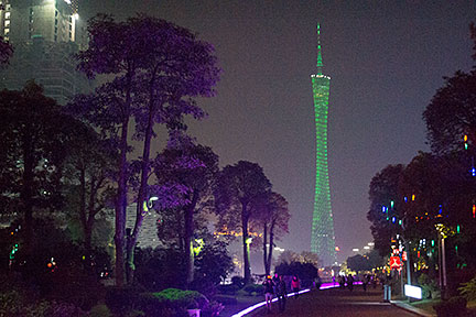 Guangzhou city at night with the illuminated 600m tall Canton Tower (Guangzhou Tower) in center. image: nationsonline.org Guangzhou has a population of more than 12 million people in its metropolitan area. The city is part of one of the most populous metropolitan agglomerations on Earth, the Pearl River Delta Mega City with a population of more than 50 million people. When you are in Guangzhou, there is a difference compared with other Asian cities, something is missing, and you can not quite explain what, until you realize: no motorbikes. The permanent noise of hundreds of motorcycles on the street is just not there. Adding up to the strange white noise of the city is the amount of hybrid cars running on electric drive mode, silent. The page shows a city map of Guangzhou with expressways, main roads and streets, zoom out to find Guangzhou Baiyun International Airport (IATA code: CAN) to the north. Just zoom in (+) to see Canton Tower, a 600m, (1,969 ft) tall multi-purpose observation tower. For some time it was the tallest tower in the world, in 2011 Tokyo's Skytree surpassed Guangzhou's Tower in height. (The satellite image is by now (Jan 2016) not congruent with the roadmap) To find a location use the form below. |
|
| To find a location type: street or place, city, optional: state, country. |
Local Time Guangzhou:
Monday-June-29 10:58
Time zone: China Standard Time (CST) UTC/GMT +8 hours |
One World - Nations Online .:. let's care for this planet Promote that every nation assumes responsibility for our world. Nations Online Project is made to improve cross-cultural understanding and global awareness. More signal - less NOISE |
| Site Map
| Information Sources | Disclaimer | Copyright © 1998-2024:: nationsonline.org |

