Nations Online
All Countries in the World
Nations Online All Countries in the World | |
Home  |
___ Satellite View and Map of the City of Fukushima (福島市), Japan |
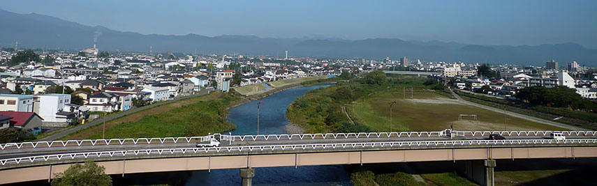 The Arakawa River flowing through Fukushima. |
About Fukushima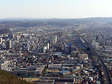 Areal view of Fukushima City. Photo: Decosu  Satellite view showing Fukushima, capital city of Fukushima Prefecture in Japan. The City is located arround Mt. Shinobu in the Fukushima Basin in the Tōhoku region, 80 km south of Sendai on Honshu, Japan's main island. The Arakawa River is flowing through the city. Satellite view showing Fukushima, capital city of Fukushima Prefecture in Japan. The City is located arround Mt. Shinobu in the Fukushima Basin in the Tōhoku region, 80 km south of Sendai on Honshu, Japan's main island. The Arakawa River is flowing through the city.Fukushima has a population of about 290,000 inhabitants. The city's economy is based on agriculture, manufacturing and service industry. Some points of interest in or near the city are Fukushima Prefectural Museum of Art (closed until March 2016), Hanamiyama Park (cherry blossom), Minka-En (parkland museum with historic buildings like Japanese inns, and silk-raising farmhouses), Iizaka Onsen and Takayu Onsen (hot springs), Goshiki-numa (volcanic lakes), Bandai-Azuma Roadway (sightseeing road to the Azuma Mountain Range). Fukushima No. I Nuclear Power Plant. After Japan's most powerful ever earthquake in recorded history on 11th March 2011, Fukushima No. I Nuclear Power Plant was hit on March 12 by a massive explosion blowing open the reactor container building, causing a plume of white smoke or steam rising above the plant, and most likely leading to radiation leaks. The Japanese government declared an “atomic power emergency” and was evacuating thousands of residents living close to Fukushima power plant. On Sunday, 13th March, the authorities had widen the emergency zone to 20 km (12.5 mi) around the nuclear power plant, affecting more than 200,000 people to be evacuated, and that in a region which is most affected by the earthquake and the ensuing tsunami. Officials tried to downplay the danger of a nuclear core meltdown, but that might also had to do with the Asian fear for loosing face. The map shows a city map of Fukushima with expressways, main roads and streets, zoom out to find the location of Fukushima Airport (IATA code: FKS), located in nearby Sukagawa, 77 km (48 mi) by road south of the city. Fukushima No. I Nuclear Power Plant is located 91 km (56.5 mi) south east of Fukushima city at the northeastern coast of Honshu island near the town of Okuma. To find a location use the form below. |
|
| To find a location type: street or place, city, optional: state, country. |
Local Time Fukushima:
Sunday-April-28 07:56
UTC/GMT +9 hours |
|
φ Latitude, λ Longitude (of Map center; move the map to see coordinates): , |
||||||
| Google Earth: Searchable Map and Satellite view of Fukushima, Fukushima Prefecture, Japan. City Coordinates: 37°46′N 140°28′E |
Bookmark/share this page |
|||||
| More about Japan: Landmarks: Mount Fuji Cities: Searchable map/satellite view of Japan's largest cities: Country: Continent: External Links: Fukushima (official city web site) Wikipedia: Fukushima City |
Weather Conditions Fukushima
|
Explore More:
Related Consumer Information:
|
||||
| Major Cities in Eastern Asia Bangkok, Beijing, Busan, Chongqing, Colombo, Delhi, Fukuoka, Guangzhou, Hanoi, Ho Chi Minh City, Hong Kong, Islamabad, Jakarta, Karachi, Kobe, Kolkata, Kuala Lumpur, Kyoto, Lahore, Lhasa, Macao, Manila, Mumbai, Nagoya, Osaka, Phnom Penh, Pyongyang, Sapporo, Seoul, Shanghai, Shenzhen, Singapore, Taipei, Tianjin, Tokyo, Ulaanbaatar, Yangon, Yokohama |
||||||
Map Help [ show ] |
||||||
One World - Nations Online .:. let's care for this planet Promote that every nation assumes responsibility for our world. Nations Online Project is made to improve cross-cultural understanding and global awareness. More signal - less NOISE |
| Site Map
| Information Sources | Disclaimer | Copyright © 1998-2023 :: nationsonline.org |

