Nations Online
All Countries in the World
Nations Online All Countries in the World | |
Home  |
___ Satellite View and Map of Hong Kong - 香港 -Xianggang (45-degree view available) |
 Hong Kong Harbor at dusk. Image: momo |
About Hong Kong Satellite view is showing Hong Kong Special Administrative Region (SAR), located south of the Chinese Guangdong (formerly Canton) province. The area comprises Hong Kong Island, the Kowloon peninsula, and the New Territories,as well as some additional areas of the mainland. Satellite view is showing Hong Kong Special Administrative Region (SAR), located south of the Chinese Guangdong (formerly Canton) province. The area comprises Hong Kong Island, the Kowloon peninsula, and the New Territories,as well as some additional areas of the mainland.Hong Kong was a former trading port, it became a crown colony of the United Kingdom in 1842, in 1997 its sovereignty was transfered to the People's Republic of China. The "One country, two systems" idea grants Hong Kong a high degree of autonomy in all areas with the exception of foreign affairs and defence. The SAR maintains its own currency, its legal and political system and other aspects that concern its way of life for at least 50 years until 2047. 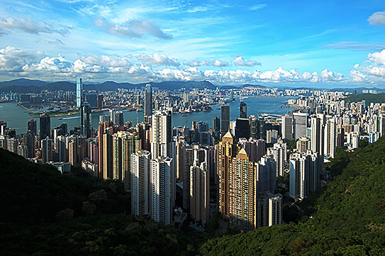 Hong Kong - view from Victoria Peak, looking north over Central, Victoria Harbor and Kowloon Image: chensiyuan Official languages are Chinese and English. Hong Kong is in Lonely Planet’s list of Best in Travel: Top 10 cities for 2012. The city is described as: "The mood in China’s most liberated city is edgier and more vocal than ever. This will be a particularly exciting year for Hong Kong, as it continues its march towards full democracy. Rallies are infused with theatrics and eruptions of song, dance and poetry, reflecting the city’s vibrant indie music and literary scenes. Enjoy views of skyscrapers marching up hills from the Star Ferry, before challenging your senses at a wet market or divining your future at a temple. Go shopping, gallery hopping and check out the bars of Soho. Explore walled villages or go hiking on Asia’s most breathtaking trails. Whatever you do, sprinkle your day generously and boldly with some of the city’s 11,000 restaurants." The Map shows a city map of Hong Kong with New Territories, Hong Kong Island, and the Kowloon peninsula with expressways, main roads and streets, as well as the location of Chek Lap Kok Airport (IATA code: HKG) on the island of Chek Lap Kok. Just zoom in (+) to see Hong Kong's International Commerce Centre, with 484 m (1,587.9 ft) the highest building in the city. To find a location like Hong Kong Disneyland use the form below. To view just the map, click on the "Map" button. |
|
| To find a location type: street or place, city, optional: state, country. |
Local Time Hong Kong:
Thursday-April-25 14:25
UTC/GMT +8 hours |
|
φ Latitude, λ Longitude (of Map center; move the map to see coordinates): , |
||||||
| Sorry! Google's pricing policy has made it impossible for us to continue showing Google Maps. We apologize for any inconvenience. Google Map: Searchable Map of the City of Hong Kong, Special Administrative Region of P.R. China. CityCoordinates: 22°16′42″N, 114°9′32″ E | Bookmark/share this page |
|||||
| More about China: History: Landmarks: Cities - City description with a searchable map and satellite view of: Beijing, Chongqing, Guangzhou, Lhasa (Tibet), Shanghai, Tianjin, Macau (SAR) Country: China key statistical data. Continent: World: |
Current Weather Conditions Hong Kong:
External Links GovHK Hong Kong Government official website. Hong Kong Tourism Board Hong Kong's official tourism website. Wikipedia: Hong Kong Wikipedia article about Hong Kong. |
Explore more:
Related Consumer Information:
|
||||
| Major Cities in Eastern Asia Bangkok, Beijing, Busan, Chongqing, Colombo, Delhi, Fukuoka, Guangzhou, Hanoi, Ho Chi Minh City, Hong Kong, Islamabad, Jakarta, Karachi, Kobe, Kolkata, Kuala Lumpur, Kyoto, Lahore, Lhasa, Macao, Manila, Mumbai, Nagoya, Osaka, Phnom Penh, Pyongyang, Sapporo, Seoul, Shanghai, Shenzhen, Singapore, Taipei, Tianjin, Tokyo, Ulaanbaatar, Yangon, Yokohama |
||||||
Map Help [ show ] |
||||||
One World - Nations Online .:. let's care for this planet Promote that every nation assumes responsibility for our world. Nations Online Project is made to improve cross-cultural understanding and global awareness. More signal - less NOISE |
| Site Map
| Information Sources | Disclaimer | Copyright © 1998-2023 :: nationsonline.org |

