Nations Online
All Countries in the World
Nations Online All Countries in the World | |
Home  |
___ Satellite View and Map of the City of Sevastopol (Севасто́поль), Ukraine |
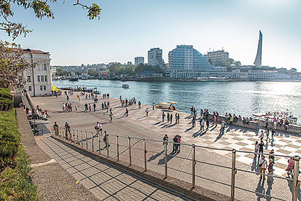
About Sevastopol Satellite view is showing Sevastopol, a major seaport in Satellite view is showing Sevastopol, a major seaport in Sevastopol was founded in 1783 as a base for a naval squadron under the name Akhtia, soon after Russia annexed the Crimean Khanate, a state ruled by Crimean Tatars from 1441 to 1783. The city's strategic position near the 'center' of the Black Sea, and its protected port made it an ideal location for a navy base, today the Ukrainian Navy as well as the Russian Black Sea Fleet are based there. In Soviet times the harbor served as a main port for the Soviet submarines. Sevastopol is a multi ethnic city with a population of about 380.000 people (est. 2013), almost 1 million people live in its urban area. There are more Russians (70%) living in the city than Ukrainians (22%) Spoken languages are Russian and Ukrainian. The map shows a city map of Sevastopol with expressways, main roads and streets, as well as the location of "Belbek" Sevastopol International Airport (IATA code: UKS) about 7 km (4.3 mi) southwest from the city center. Sevastopol's harbor is to the north, nearby are the Potemkin Stairs, the giant stairway is the formal entrance leading from the port into the city. To find a location use the form below. |
|
| To find a location type: street or place, city, optional: state, country. |
Local Time Ukraine:
Wednsday-July-22 12:10
Standard Time: UTC/GMT +2 hours.Daylight saving time from end of March till end of October: UTC/GMT +3 hours. |
|
φ Latitude, λ Longitude (of Map center; move the map to see coordinates): , |
||||||
| Google Earth: Searchable Map and Satellite view of Sevastopol (Севасто́поль), Ukraine. City Coordinates: 44°36′N 33°32′E |
Bookmark/share this page |
|||||
| More about Ukraine: Cities: Country: Continent: External Links Sevastopol (official web site) Wikipedia: Sevastopol |
Current Weather Conditions : (nearest working weather station is currently at Simferopol International Airport)
|
Related Consumer Information:
|
||||
Maps of other countries and regions in Central and Eastern Europe Belarus Map, Bulgaria Map, Czech Republic Map, Hungary Map, Moldova Map, Poland Map, Romania Map, Slovakia Map Interactive Maps of other countries and regions in Central and Eastern Europe Belarus Interactive Map, Bulgaria Interactive Map, Czech Interactive Republic Map, Hungary Interactive Map, Moldova Interactive Map, Poland Interactive Map, Romania Interactive Map, Slovakia Interactive Map Other Cities in Eastern Europe: Bratislava | Bucharest | Budapest | Chisinau | Minsk | Moscow | Prague | Sofia | Warsaw Countries and Territories of Europe |
||||||
Map Help [ show ] |
||||||
One World - Nations Online .:. let's care for this planet Promote that every nation assumes responsibility for our world. Nations Online Project is made to improve cross-cultural understanding and global awareness. More signal - less NOISE |
| Site Map
| Information Sources | Disclaimer | Copyright © 1998-2024:: nationsonline.org |