Nations Online
All Countries in the World
Nations Online All Countries in the World | |
Home  |
___ Satellite View and Map of Slovakia (Slovensko) |
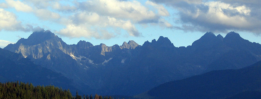 The highest peaks of the Tatra mountain range, from left: Gerlachovsky Stit, Batyżowiecki, Kaczy, Kończysta, Ganek, Wysoka, Rysy. Image: Pibwl |
About Slovakia Slovakia is a landlocked country in central Europe and until 1993 part of the former sovereign state of Czechoslovakia. The Morava river forms part of the Slovak border with the Czech Republic and Austria, the Danube is the largest river which flows through the country, it actually forms parts of the border with Austria and Hungary, the longest river within Slovakia is the Váh River. Other border countries are Poland, and the Ukraine. Slovakia is a landlocked country in central Europe and until 1993 part of the former sovereign state of Czechoslovakia. The Morava river forms part of the Slovak border with the Czech Republic and Austria, the Danube is the largest river which flows through the country, it actually forms parts of the border with Austria and Hungary, the longest river within Slovakia is the Váh River. Other border countries are Poland, and the Ukraine.Slovakia occupies an area of 49,035 km², making the country somewhat larger than half the size of Portugal or about twice the size of the U.S. state New Hampshire. The country's landscape consist of rugged mountains in the central and northern part and lowlands in south. The highest peak is Gerlachovsky Stit with 2,655 m, the mountain is located in the High Tatras, a mountain range that forms a natural border between Slovakia and Poland. The country has a population of 5.4 million people (in 2015), Slovakia's national capital is Slovakia is divided into eight regions: Bratislava, Trnava, Trenčín, Nitra, Žilina, Banská Bystrica, Prešov, and Košice. The Regions are named after their Region capitals. The map shows Slovakia with international borders, Regions (kraje) boundaries (the red dashed lines), cities, towns, expressways, main roads and streets. To find a location use the form below. To view just the map, click on the "Map" button. |
| To find a location type: street or place, city, optional: state, country. |
|
φ Latitude, λ Longitude (of Map center; move the map to see coordinates): , |
||||||
| Google Maps: Searchable Map of Slovak Republic. |
||||||
| More about Slovakia: Cities: Country: Continent: |
Current Weather Conditions Bratislava
|
Related Consumer Information:
|
||||
Maps of other countries and regions in Central and Eastern Europe Belarus Map, Bulgaria Map, Czech Republic Map, Hungary Map, Moldova Map, Poland Map, Romania Map, Ukraine Map Interactive Maps of other countries and regions in Central and Eastern Europe Belarus Interactive Map, Bulgaria Interactive Map, Czech Interactive Republic Map, Hungary Interactive Map, Moldova Interactive Map, Poland Interactive Map, Romania Interactive Map, Ukraine Interactive Map Major Cities in Eastern Europe: Bratislava | Bucharest | Budapest | Chisinau | Kiev | Minsk | Moscow | Prague | Sofia | Warsaw Countries and Territories of Europe |
||||||
Map Help [ show ] |
||||||
One World - Nations Online .:. let's care for this planet Promote that every nation assumes responsibility for our world. Nations Online Project is made to improve cross-cultural understanding and global awareness. More signal - less NOISE |
| Site Map
| Information Sources | Disclaimer | Copyright © 1998-2024:: nationsonline.org |

